alb4859764
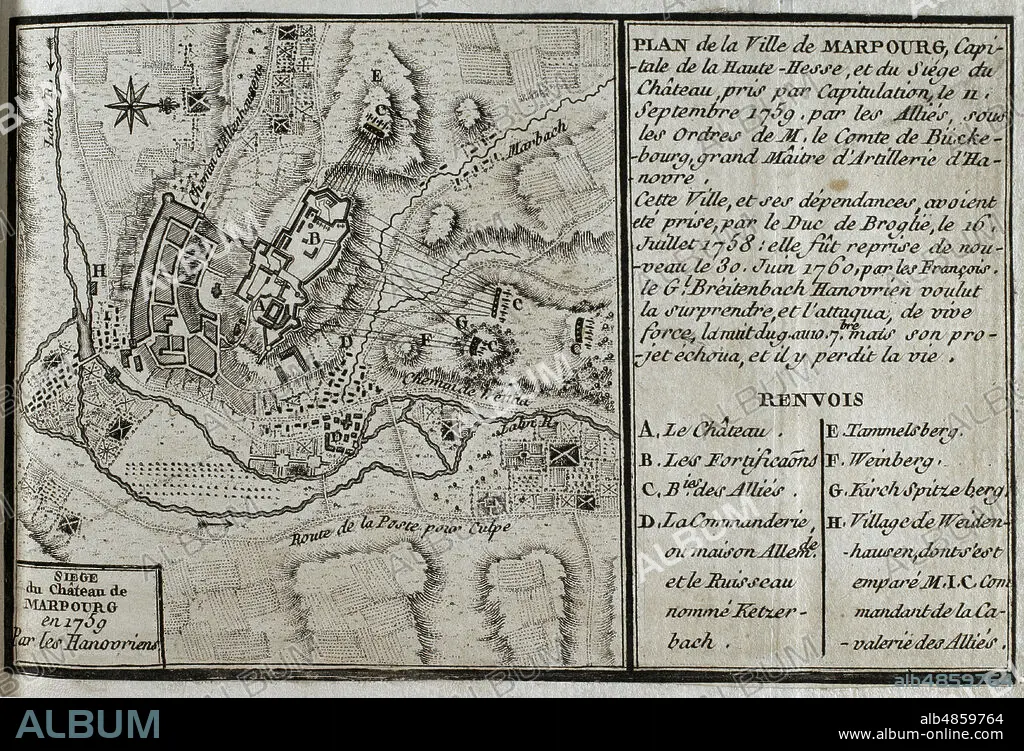
JEAN DE BEAURAIN (1696-1771). FRENCH GEOGRAPHER.. Seven Years War (1756-1763). Map of Marburg and siege of the castle, 1759. Taken by capitulation on 11 September 1759 by the Allied forces under the command of the Count of Buckeburg. Marburg had been captured by the Duke of Broglie on 16 July 1758, being seized again by the French on 30 June 1760. Published in 1765 by the cartographer Jean de Beaurain (1696-1771) as an illustration of his Great Map of Germany, with the events that took place during the Seven Years War. Etching and engraving. French edition, 1765. Military Historical Library of Barcelona (Biblioteca Histórico Militar de Barcelona). Catalonia. Spain.
| Teilen |
|---|
 Pinterest Pinterest |
 Twitter Twitter |
 Facebook Facebook |
 Link kopieren Link kopieren |
 Email Email |
|
Zu einem anderen Lightbox hinzufügen |
|
Zu einem anderen Lightbox hinzufügen |


Haben Sie bereits ein Konto? Anmelden
Sie haben kein Konto? Registrieren
Dieses Bild kaufen

Untertitel:
Siehe automatische Übersetzung
Seven Years War (1756-1763). Map of Marburg and siege of the castle, 1759. Taken by capitulation on 11 September 1759 by the Allied forces under the command of the Count of Buckeburg. Marburg had been captured by the Duke of Broglie on 16 July 1758, being seized again by the French on 30 June 1760. Published in 1765 by the cartographer Jean de Beaurain (1696-1771) as an illustration of his Great Map of Germany, with the events that took place during the Seven Years War. Etching and engraving. French edition, 1765. Military Historical Library of Barcelona (Biblioteca Histórico Militar de Barcelona). Catalonia. Spain.
Standort:
Historical Military Library of Barcelona. Catalonia. Spain.
Bildnachweis:
Album / Prisma
Freigaben (Releases):
Model: Nein - Eigentum: Nein
Rechtefragen?
Rechtefragen?
Bildgröße:
4687 x 3193 px | 42.8 MB
Druckgröße:
39.7 x 27.0 cm | 15.6 x 10.6 in (300 dpi)
Schlüsselwörter:
11. SEPTEMBER 2001 • 18. JAHRHUNDERT • 18. JH. • ARMEE, FRANZOESISCHE • BELAGERUNG • DEUTSCH • DEUTSCHLAND • EUROPA • EUROPAEER (F M) • EUROPAEER • EUROPÄER (F M) • EUROPÄER • EUROPÄISCH • FEUER, KRIEG • FRANZOESISCHE ARMEE • GESCHICHTE • GRAVUR • HESSE • HISTORICAL MILITARY LIBRARY OF BARCELONA. CATALONIA. SPAIN. • JEAN DE BEAURAIN (1696-1771). FRENCH GEOGRAPHER. • KARTE (KARTHOGRAFIE) • KARTEN • KARTHOGRAFIE • KARTHOGRAPHIE • KARTOGRAFIE (KARTE) • KARTOGRAPHIE • KONFLIKT • KONFLIKTE • KRIEG • KRIEG: BELAGERUNG • LANDKARTE • MARBURG • PLAN (KARTOGRAPHIE) • SIEBENJAEHRIGER KRIEG • SIEBENJÄHRIGER KRIEG • STICH (KUNST) • WISSENSCH.: KARTOGRAPHIE • ZEITGESCHICHTE
