alb1655975
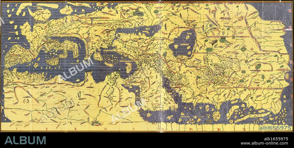
The 'Kitab Rudjdjar' or 'Tabula Rogeriana', an early world map the work of the Arab geographer Muhammad al-Idrisi (1100-1165) in 1154 for Roger II (1095-1154) King of Sicily from 1130. In this map, North is at the bottom.
| Teilen |
|---|
 Pinterest Pinterest |
 Twitter Twitter |
 Facebook Facebook |
 Link kopieren Link kopieren |
 Email Email |
|
Zu einem anderen Lightbox hinzufügen |
|
Zu einem anderen Lightbox hinzufügen |


Haben Sie bereits ein Konto? Anmelden
Sie haben kein Konto? Registrieren
Dieses Bild kaufen

Untertitel:
Siehe automatische Übersetzung
The 'Kitab Rudjdjar' or 'Tabula Rogeriana', an early world map the work of the Arab geographer Muhammad al-Idrisi (1100-1165) in 1154 for Roger II (1095-1154) King of Sicily from 1130. In this map, North is at the bottom.
Bildnachweis:
Album / Universal History Archive/Universal Images Group
Freigaben (Releases):
Model: Nein - Eigentum: Nein
Rechtefragen?
Rechtefragen?
Bildgröße:
6284 x 2850 px | 51.2 MB
Druckgröße:
53.2 x 24.1 cm | 20.9 x 9.5 in (300 dpi)
Schlüsselwörter:
12. JAHRHUNDERT • 12. JH. • ARABISCH • ERKUNDUNG • GEOGRAFIE • GEOGRAPH • GEOGRAPHIE • KARTE (KARTHOGRAFIE) • KARTEN • KARTHOGRAFIE • KARTHOGRAPHIE • KARTOGRAFIE (KARTE) • KARTOGRAPHIE • KOENIG • KÖNIG • LANDKARTE • NORDEN • PLAN (KARTOGRAPHIE) • WELT • WISSENSCH.: KARTOGRAPHIE
