alb3846937
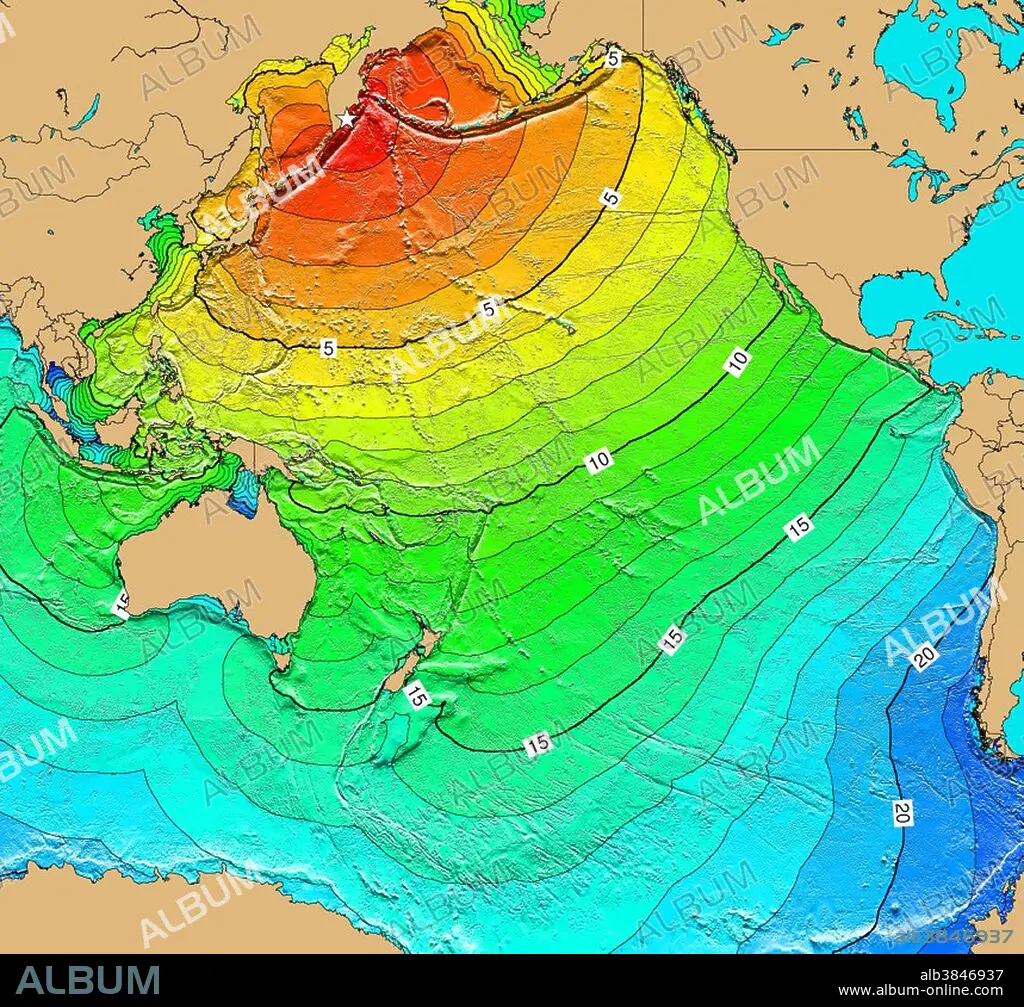
Tsunami Map, Kamchatka Earthquake, 1952
| Teilen |
|---|
 Pinterest Pinterest |
 Twitter Twitter |
 Facebook Facebook |
 Link kopieren Link kopieren |
 Email Email |
|
Zu einem anderen Lightbox hinzufügen |
|
Zu einem anderen Lightbox hinzufügen |


Haben Sie bereits ein Konto? Anmelden
Sie haben kein Konto? Registrieren
Dieses Bild kaufen

Titel:
Tsunami Map, Kamchatka Earthquake, 1952
Untertitel:
Siehe automatische Übersetzung
The magnitude 9.0 Mw earthquake on November 4, 1952 off the east coast of Kamchatka generated a 13-meter wave locally. The waves struck the Hawaiian Islands at 1:00 pm. Property damage from these waves in the Hawaiian Islands was estimated at $800,000 to $1,000,000; however no lives were lost. It also caused damage on the west coast of the United States and was observed on tide gauges throughout the Pacific Basin. Map generated using Tsunami Travel Time (TTT) software: calculates first-arrival travel times on a grid for a tsunami generated at an earthquake epicenter. Map contours: 1 hour intervals: red 1-4 hour arrival times, yellow: 5-6 hour arrival times, green: 7-14 hour arrival times, blue: 15-21 hour arrival times. Maps were generated from earthquake epicenters in the NGDC Global Historical Tsunami Database using NGDC 2 Minute Gridded Global Relief Data bathymetry. Maps do not provide the height or the strength of the wave, only the arrival times.
Bildnachweis:
Album / NOAA/Science Source
Freigaben (Releases):
Model: Nein - Eigentum: Nein
Rechtefragen?
Rechtefragen?
Bildgröße:
3900 x 3632 px | 40.5 MB
Druckgröße:
33.0 x 30.8 cm | 13.0 x 12.1 in (300 dpi)
Schlüsselwörter:
BERÜHMT • BERÜHMTE PERSÖNLICHKEIT • EREIGNIS • GEOLOGIE • HYDROGRAPHIE • KARTE • MEER • MEERE • NOTABEL • OZEAN • PROMINENZ • SEA • SEESTUECK (GEMAELDE) • TECHNOLOGIE • TSUNAMI
