alb1474307
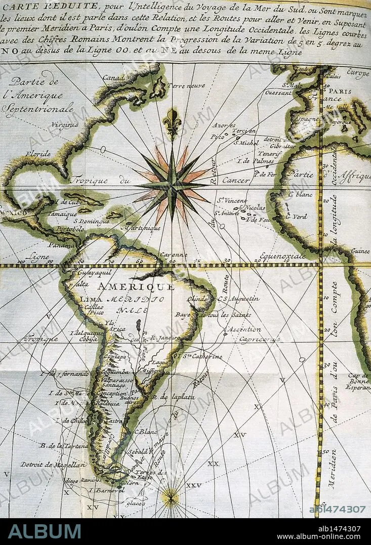
Map of the Atlantic Ocean from Newfoundland to Cape Horn. At A Voyage to the South-sea and along the coasts of Chili and Peru, in the years 1712, 1713 and 1714 by Amedee-Franc_ois Frezier (1682-1773). Published in Paris, 1716. Library of Catalonia. Barcelona. Spain.
| Teilen |
|---|
 Pinterest Pinterest |
 Twitter Twitter |
 Facebook Facebook |
 Link kopieren Link kopieren |
 Email Email |
|
Zu einem anderen Lightbox hinzufügen |
|
Zu einem anderen Lightbox hinzufügen |


Haben Sie bereits ein Konto? Anmelden
Sie haben kein Konto? Registrieren
Dieses Bild kaufen

Untertitel:
Siehe automatische Übersetzung
Map of the Atlantic Ocean from Newfoundland to Cape Horn. At A Voyage to the South-sea and along the coasts of Chili and Peru, in the years 1712, 1713 and 1714 by Amedee-Franc_ois Frezier (1682-1773). Published in Paris, 1716. Library of Catalonia. Barcelona. Spain.
Bildnachweis:
Album / Kurwenal / Prisma
Freigaben (Releases):
Model: Nein - Eigentum: Nein
Rechtefragen?
Rechtefragen?
Bildgröße:
4466 x 6239 px | 79.7 MB
Druckgröße:
37.8 x 52.8 cm | 14.9 x 20.8 in (300 dpi)
Schlüsselwörter:
18. JAHRHUNDERT • 18. JH. • AFRIKA • AFRIKANER • AFRIKANERIN • AFRIKANISCH • AMERIKA • AMERIKA, KONTINENT • AMERIKANERIN • AMERIKANISCH • ATLANTIK • ATLANTISCHER OZEAN • BARCELONA • CHILISCHOTE • EUROPA • EUROPAEER (F M) • EUROPAEER • EUROPÄER (F M) • EUROPÄER • EUROPÄISCH • FRANKREICH • GESCHICHTE • HIMMELSKREIS • INSEL • ITALIEN • KARTE (KARTHOGRAFIE) • KARTEN • KARTHOGRAFIE • KARTHOGRAPHIE • KARTOGRAFIE (KARTE) • KARTOGRAPHIE • KATALONIEN • KONTINENT • KONTINENT: AMERIKA • KUESTE • KÜSTE • LANDKARTE • LATEINAMERIKANISCH • MARITIM • MEER • MEERE • MERIDIAN • OZEAN • PARIS • PARIS, FRANKREICH • PLAN (KARTOGRAPHIE) • REISE • REISENDER • SEA • SEESTUECK (GEMAELDE) • SÜDAMERIKA • TECHNIK: ZEICHNUNG • WALZ • WISSENSCH.: KARTOGRAPHIE • ZEICHNEN • ZEICHNUNG • ZEITGESCHICHTE
