alb5371914
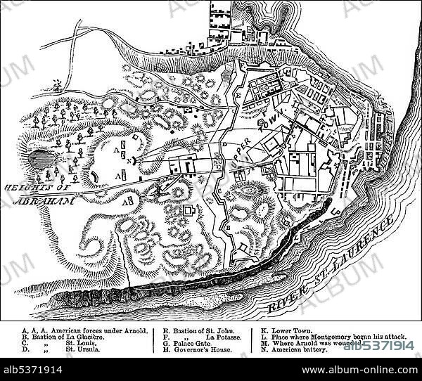
Historical drawing, US-American history, 18th century, map of the Battle of Quebec, 31st December 1775, between the British and the Americans in the Revolutionary War, near Quebec, Canada, North America.
| Teilen |
|---|
 Pinterest Pinterest |
 Twitter Twitter |
 Facebook Facebook |
 Link kopieren Link kopieren |
 Email Email |
|
Zu einem anderen Lightbox hinzufügen |
|
Zu einem anderen Lightbox hinzufügen |


Haben Sie bereits ein Konto? Anmelden
Sie haben kein Konto? Registrieren
Dieses Bild kaufen

Untertitel:
Siehe automatische Übersetzung
Historical drawing, US-American history, 18th century, map of the Battle of Quebec, 31st December 1775, between the British and the Americans in the Revolutionary War, near Quebec, Canada, North America
Persönlichkeiten:
Bildnachweis:
Album / ImageBroker / H.-D. Falkenstein
Freigaben (Releases):
Model: Nein - Eigentum: Nein
Rechtefragen?
Rechtefragen?
Bildgröße:
600 x 509 px | 894.7 KB
Druckgröße:
5.1 x 4.3 cm | 2.0 x 1.7 in (300 dpi)
Schlüsselwörter:
18. JAHRHUNDERT • 18. JH. • AMERIKANISCH (US) • DEZEMBER • FEUER, KRIEG • KANADA • KARTE • KARTEN • KRIEG • PAPPE • PLAN • SCHWARZ-WEISS • US-AMERIKANISCH • USA • USA-VEREINIGE STAATEN • ZEICHNUNGEN
