alb3609549
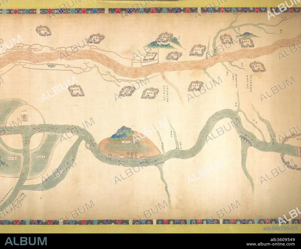
UNIDENTIFIED ARTIST CHINESE, LATE 18TH OR EARLY 19TH CENTURY. Map of the Grand Canal from Beijing to the Yangzi River
| Teilen |
|---|
 Pinterest Pinterest |
 Twitter Twitter |
 Facebook Facebook |
 Link kopieren Link kopieren |
 Email Email |
|
Zu einem anderen Lightbox hinzufügen |
|
Zu einem anderen Lightbox hinzufügen |


Haben Sie bereits ein Konto? Anmelden
Sie haben kein Konto? Registrieren
Dieses Bild kaufen

Titel:
Map of the Grand Canal from Beijing to the Yangzi River
Untertitel:
Siehe automatische Übersetzung
Map of the Grand Canal from Beijing to the Yangzi River. Artist: Unidentified Artist Chinese, late 18th or early 19th century. Culture: China. Dimensions: Image: 21 7/8 in. × 30 ft. 7 in. (55.6 × 932.2 cm)
Overall: H. 32 1/4 in. (81.9 cm). Date: late 18th or early 19th century.
Managing China's complex network of rivers, canals, and irrigation systems has been one of the abiding concerns of its rulers. From the fourteenth century, the Grand Canal served as the major artery for transporting grain from the wealthy agricultural regions south of the Yangzi River to the capital city of Beijing in the north. Of equal importance was the constant threat of flooding from the Yellow River and other river systems that traversed the canal. Under the Manchu Qing dynasty (1644-1911), both the Kangxi (r. 1662-1722) and Qianlong (r. 1736-95) emperors personally inspected the hydraulic management measures in this region on their periodic tours of the empire.
This map follows the course of the Grand Canal from the vicinity of Beijing southward to the Yangzi River. Artistically, it stands halfway between modern cartographic records and the more pictorial approach to mapmaking that was commonly used prior to the twentieth century in China. While most elements are schematically rendered, images of the Forbidden City, the Yangzi River, and certain mountains and topographic features are treated in pictorial terms. All of the rivers, canals, dams, sluice gates, dikes, and catchment basins as well as the walled cities and important towns situated near the canal are depicted and labeled. The linchpin of the entire hydraulic system was the confluence of the Yellow and Huai Rivers with the Grand Canal. Based on documented changes to the configuration of the Huang-Huai confluence and other areas, the content of the map can be dated to the period from 1737 to 1761.
Technik/Material:
Handscroll; ink and color on silk
Zeitraum:
Qing dynasty (1644-1911)
Museum:
Metropolitan Museum of Art, New York, USA
Bildnachweis:
Album / Metropolitan Museum of Art, NY
Freigaben (Releases):
Model: Nein - Eigentum: Nein
Rechtefragen?
Rechtefragen?
Bildgröße:
4258 x 3314 px | 40.4 MB
Druckgröße:
36.1 x 28.1 cm | 14.2 x 11.0 in (300 dpi)
