alb1651927
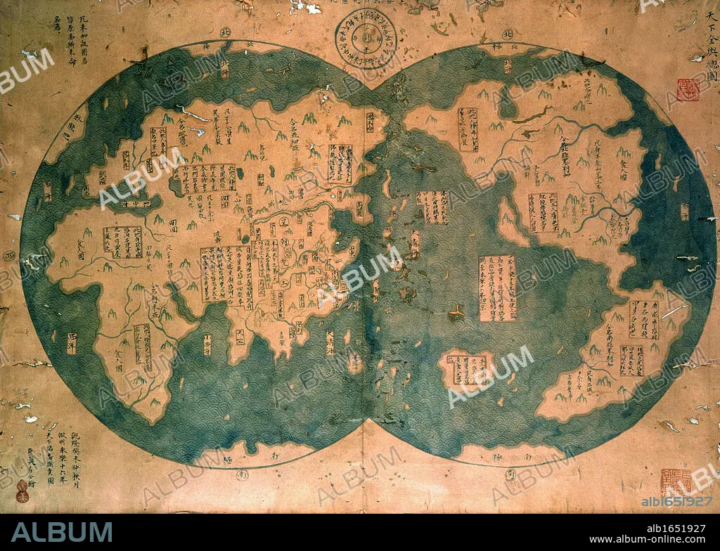
Chinese map of the world dated 1763, claiming to be a reproduction of a 1418 map of Zheng He's (1371-1433) voyages and to prove that Zheng He sailed both to Australia and the Americas. Many think the map is more likely to be based on 18th century European maps. Discovered by Lui Gang in 2005.
| Teilen |
|---|
 Pinterest Pinterest |
 Twitter Twitter |
 Facebook Facebook |
 Link kopieren Link kopieren |
 Email Email |
|
Zu einem anderen Lightbox hinzufügen |
|
Zu einem anderen Lightbox hinzufügen |


Haben Sie bereits ein Konto? Anmelden
Sie haben kein Konto? Registrieren
Dieses Bild kaufen

Untertitel:
Automatische Übersetzung: Chinesische Weltkarte aus dem Jahr 1763, die angeblich eine Reproduktion einer Karte von Zheng Hes (1371-1433) Reisen aus dem Jahr 1418 darstellt und beweist, dass Zheng He sowohl nach Australien als auch nach Amerika segelte. Viele gehen davon aus, dass die Karte eher auf europäischen Karten des 18. Jahrhunderts basiert. 2005 von Lui Gang entdeckt
Chinese map of the world dated 1763, claiming to be a reproduction of a 1418 map of Zheng He's (1371-1433) voyages and to prove that Zheng He sailed both to Australia and the Americas. Many think the map is more likely to be based on 18th century European maps. Discovered by Lui Gang in 2005.
Bildnachweis:
Album / Universal Images Group / Universal History Archive
Freigaben (Releases):
Model: Nein - Eigentum: Nein
Rechtefragen?
Rechtefragen?
Bildgröße:
3533 x 2523 px | 25.5 MB
Druckgröße:
29.9 x 21.4 cm | 11.8 x 8.4 in (300 dpi)
Schlüsselwörter:
15. JAHRHUNDERT • 15. JH. • 18. JAHRHUNDERT • 18. JH. • AMERIKA • AMERIKA, KONTINENT • CHINESIN • CHINESISCH • ENTDECKUNG • ERKUNDUNG • EUROPAEER (F M) • EUROPAEER • EUROPÄER (F M) • EUROPÄER • EUROPÄISCH • GEOGRAFIE • GEOGRAPHIE • KARTE (KARTHOGRAFIE) • KARTEN • KARTHOGRAFIE • KARTHOGRAPHIE • KARTOGRAFIE (KARTE) • KARTOGRAPHIE • KONTINENT: AMERIKA • LANDKARTE • PLAN (KARTOGRAPHIE) • WELT • WISSENSCH.: KARTOGRAPHIE
