alb3826617
Tsunami Map, Great Lisbon Earthquake, 1755
| Teilen |
|---|
 Pinterest Pinterest |
 Twitter Twitter |
 Facebook Facebook |
 Link kopieren Link kopieren |
 Email Email |
|
Zu einem anderen Lightbox hinzufügen |
|
Zu einem anderen Lightbox hinzufügen |


Haben Sie bereits ein Konto? Anmelden
Sie haben kein Konto? Registrieren
Dieses Bild kaufen

Titel:
Tsunami Map, Great Lisbon Earthquake, 1755
Untertitel:
Siehe automatische Übersetzung
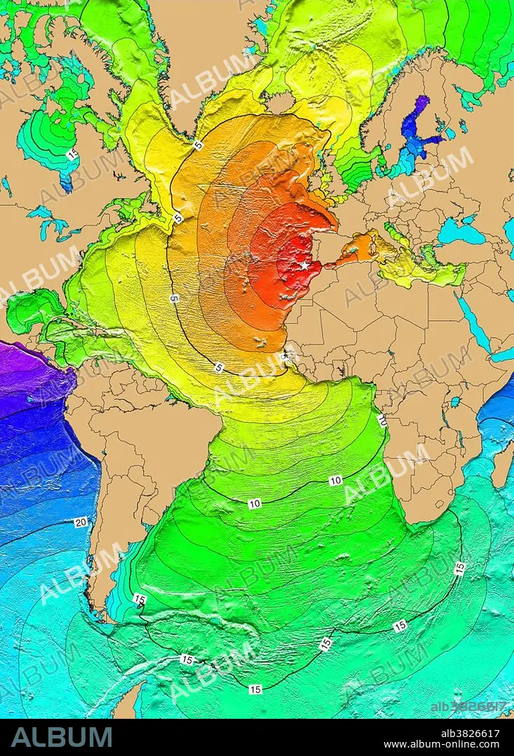
November 1, 1755 Lisbon, Portugal. A large earthquake, Modified Mercalli Intensity XI, in Lisbon, Portugal, caused damage to north of Granada, Spain. The earthquake generated a tsunami that affected the coasts of Portugal, Spain, North Africa, and the Caribbean. The tsunami reached Lisbon about 20 minutes after the first destructive shock. It rose to about 6 meters at many points along the Portuguese coast and reached 12 meters in some places. It also affected the coast of Morocco where the streets of Safi were flooded. The tsunami reached Antigua about 9.3 hours after the earthquake. Later waves, with estimated run-up heights of 7 meters, were observed at Saba, Netherlands, Antilles. The earthquake and tsunami killed between 60,000 and 100,000 people. Map generated using Tsunami Travel Time (TTT) software: calculates first-arrival travel times on a grid for a tsunami generated at an earthquake epicenter. Map contours: 1 hour intervals: red 1-4 hour arrival times, yellow: 5-6 hour arrival times, green: 7-14 hour arrival times, blue: 15-21 hour arrival times. Maps were generated from earthquake epicenters in the NGDC Global Historical Tsunami Database using NGDC 2 Minute Gridded Global Relief Data bathymetry. Maps do not provide the height or the strength of the wave, only the arrival times.
Bildnachweis:
Album / NOAA/Science Source
Freigaben (Releases):
Model: Nein - Eigentum: Nein
Rechtefragen?
Rechtefragen?
Bildgröße:
3008 x 4200 px | 36.1 MB
Druckgröße:
25.5 x 35.6 cm | 10.0 x 14.0 in (300 dpi)
Schlüsselwörter:
18. JAHRHUNDERT • 18. JH. • ATLANTIK • ATLANTISCHER OZEAN • BERÜHMT • BERÜHMTE PERSÖNLICHKEIT • EREIGNIS • GEOLOGIE • GESCHICHTE, PORTUGAL • HYDROGRAPHIE • KARTE • NOTABEL • PORTUGAL • PROMINENZ • TECHNOLOGIE • TSUNAMI
