alb5528489
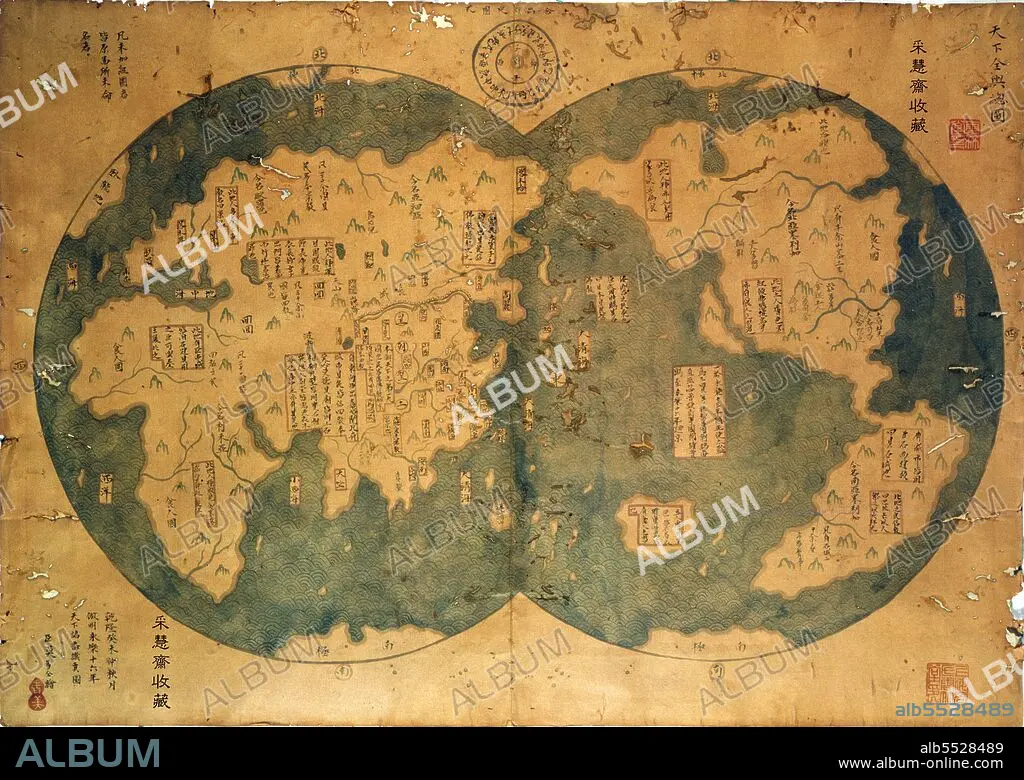
China: The Mo Yi Tong 1763 world map, supposedly copying a world chart made in 1418 based on the voyages of Zheng He, but widely assumed to be a later-perhaps 18th century-fake.
| Teilen |
|---|
 Pinterest Pinterest |
 Twitter Twitter |
 Facebook Facebook |
 Link kopieren Link kopieren |
 Email Email |
|
Zu einem anderen Lightbox hinzufügen |
|
Zu einem anderen Lightbox hinzufügen |


Haben Sie bereits ein Konto? Anmelden
Sie haben kein Konto? Registrieren
Dieses Bild kaufen

Titel:
China: The Mo Yi Tong 1763 world map, supposedly copying a world chart made in 1418 based on the voyages of Zheng He, but widely assumed to be a later-perhaps 18th century-fake.
Untertitel:
Siehe automatische Übersetzung
The Mo Yi Tong Map or 'Zheng He Map' was purchased from a Shanghai dealer in 2001 by a Chinese lawyer, Liu Gang, for US$500. Despite initial claims that the map was based on an earlier 1418 map drawn after the observations of Zheng He, the Ma Yi Tong map has been generally discredited as an 18th century forgery. This analysis is based on the use of several modern Chinese characters, as well as the extensive mapping of Australia, North America and even Antartica, as well as the representation of California as an island which seems to have been copied from 17th century French cartographers. Finally, China was always represented as the centre of the world in Chinese cartography until the ground-breaking 'Selden Map', c. 1624 CE (see CPA0022438).
Bildnachweis:
Album / Pictures from History/Universal Images Group
Freigaben (Releases):
Model: Nein - Eigentum: Nein
Rechtefragen?
Rechtefragen?
Bildgröße:
5000 x 3548 px | 50.8 MB
Druckgröße:
42.3 x 30.0 cm | 16.7 x 11.8 in (300 dpi)
Schlüsselwörter:
