alb4859291
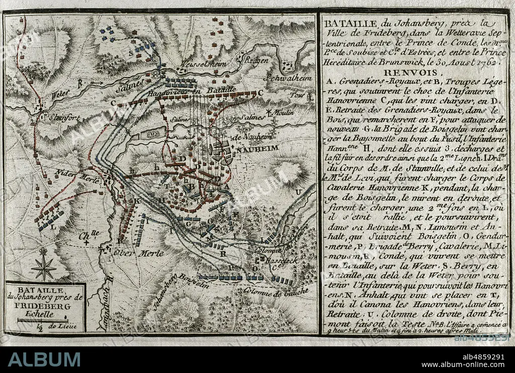
JEAN DE BEAURAIN (1696-1771). FRENCH GEOGRAPHER.. Seven Years War (1756-1763). Map of the Battle of Johannisberg, 1762 (August 30, 1762). French forces led by Louis Joseph, Prince of Conde, defeated Hanoverian and British army under the command of Duke Ferdinand of Brunswick. Published in 1765 by the cartographer Jean de Beaurain (1696-1771) as an illustration of his Great Map of Germany, with the events that took place during the Seven Years War. Allied army in red and the French army in blue. Etching and engraving. French edition, 1765. Military Historical Library of Barcelona (Biblioteca Histórico Militar de Barcelona). Catalonia. Spain.
| Teilen |
|---|
 Pinterest Pinterest |
 Twitter Twitter |
 Facebook Facebook |
 Link kopieren Link kopieren |
 Email Email |
|
Zu einem anderen Lightbox hinzufügen |
|
Zu einem anderen Lightbox hinzufügen |


Haben Sie bereits ein Konto? Anmelden
Sie haben kein Konto? Registrieren
Dieses Bild kaufen

Untertitel:
Siehe automatische Übersetzung
Seven Years War (1756-1763). Map of the Battle of Johannisberg, 1762 (August 30, 1762). French forces led by Louis Joseph, Prince of Conde, defeated Hanoverian and British army under the command of Duke Ferdinand of Brunswick. Published in 1765 by the cartographer Jean de Beaurain (1696-1771) as an illustration of his Great Map of Germany, with the events that took place during the Seven Years War. Allied army in red and the French army in blue. Etching and engraving. French edition, 1765. Military Historical Library of Barcelona (Biblioteca Histórico Militar de Barcelona). Catalonia. Spain.
Standort:
Historical Military Library of Barcelona. Catalonia. Spain.
Bildnachweis:
Album / Prisma
Freigaben (Releases):
Model: Nein - Eigentum: Nein
Rechtefragen?
Rechtefragen?
Bildgröße:
4669 x 3148 px | 42.1 MB
Druckgröße:
39.5 x 26.7 cm | 15.6 x 10.5 in (300 dpi)
Schlüsselwörter:
18. JAHRHUNDERT • 18. JH. • DEUTSCHLAND • ENGLAND: GESCHICHTE • EUROPA • EUROPAEER (F M) • EUROPAEER • EUROPÄER (F M) • EUROPÄER • EUROPÄISCH • FEUER, KRIEG • FRANKREICH • FRANKREICH: GESCHICHTE • GESCHICHTE ENGLAND • GESCHICHTE FRANKREICH • GESCHICHTE • GESCHICHTE, ENGLAND • GESCHICHTE, FRANKREICH • GRAVUR • HESSE • HISTORICAL MILITARY LIBRARY OF BARCELONA. CATALONIA. SPAIN. • JEAN DE BEAURAIN (1696-1771). FRENCH GEOGRAPHER. • JOHANNISBERG • KARTE (KARTHOGRAFIE) • KARTEN • KARTHOGRAFIE • KARTHOGRAPHIE • KARTOGRAFIE (KARTE) • KARTOGRAPHIE • KOLONIALISMUS • KOLONIALKRIEGE • KONFLIKT • KONFLIKTE • KRIEG IN DEN KOLONIEN • KRIEG • LANDKARTE • PLAN (KARTOGRAPHIE) • SCHLACHT VON BORODINO • SCHLACHT • SCHLACHTFELD • SIEBENJAEHRIGER KRIEG • SIEBENJÄHRIGER KRIEG • STICH (KUNST) • STRATEGIE • WISSENSCH.: KARTOGRAPHIE • ZEITGESCHICHTE
