alb3831583
Pacific ring of fire
| Teilen |
|---|
 Pinterest Pinterest |
 Twitter Twitter |
 Facebook Facebook |
 Link kopieren Link kopieren |
 Email Email |
|
Zu einem anderen Lightbox hinzufügen |
|
Zu einem anderen Lightbox hinzufügen |


Haben Sie bereits ein Konto? Anmelden
Sie haben kein Konto? Registrieren
Dieses Bild kaufen

Titel:
Pacific ring of fire
Untertitel:
Siehe automatische Übersetzung
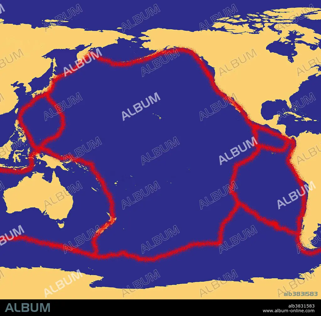
Map of the Pacific, showing the 'Ring of Fire,' which follows the contours of the tectonic plates (in red). About 90% of the world's earthquakes and 81% of the world's largest earthquakes occur along the Ring of Fire, which is also home to over 75% of the world's active and dormant volcanoes. This intense seismic and volcanic activity is caused by the movement of tectonic plates in the Earth's crust under the ocean moving against those under the land.
Bildnachweis:
Album / Science Source / Jessica Wilson/NASA
Freigaben (Releases):
Model: Nein - Eigentum: Nein
Rechtefragen?
Rechtefragen?
Bildgröße:
3300 x 3075 px | 29.0 MB
Druckgröße:
27.9 x 26.0 cm | 11.0 x 10.2 in (300 dpi)
Schlüsselwörter:
AKTIV • ASIEN • ASIEN, KONTINENT • FEUER • FEUER, VIER ELEMENTE • GEGEND • GEOLOGIE • ILLUSTRATION • ILLUSTRATIONS • JAPAN • JAPANER • JAPANERIN • JAPANISCH • KONTINENT, ASIEN • MALAYSIA • MEER • MEERE • ORMNAMENT: JAPANISCH • OZEAN • OZEANIEN • SEA • SEESTUECK (GEMAELDE) • SUEDEN • SÜDEN • VIER ELEMENTE: FEUER • VULKAN • WELT
