alb5411596
Colonial Transatlantic Trade, Map
| Share |
|---|
 Pinterest Pinterest |
 Twitter Twitter |
 Facebook Facebook |
 Copy link Copy link |
 Email Email |
|
Add to another lightbox |
|
Add to another lightbox |


Title:
Colonial Transatlantic Trade, Map
Caption:
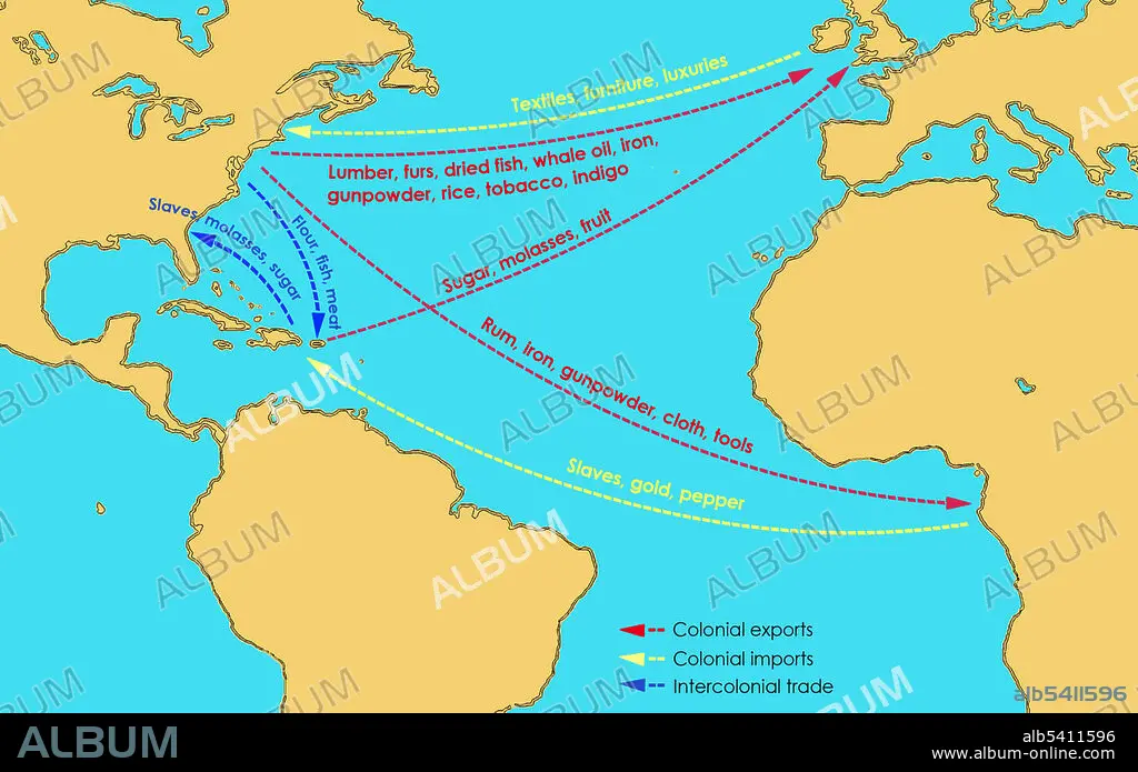
A map showing the flow of goods to and from the Thirteen British Colonies in North America in the 17th and 18th centuries. Britain exported manufactured goods, textiles, furniture, and luxuries to the Colonies; from the Colonies and the West Indies, they imported sugar, molases, fruit, lumber, furs, dried fish, whale oil, iron, gunpowder, rice, tobacco, and indigo. The Colonies exported rum, iron, gunpowder, cloth, and tools to Africa. Slaves, gold and pepper were transported from Africa, while intercolonial trade (to and from the West Indies and the Colonies) included slaves, molasses, sugar, flour, fish, and meat.
Credit:
Album / Science Source / Jessica Wilson
Releases:
Model: No - Property: No
Rights questions?
Rights questions?
Image size:
3000 x 1881 px | 16.1 MB
Print size:
25.4 x 15.9 cm | 10.0 x 6.3 in (300 dpi)
Keywords:
13 COLONIES • 17TH CENTURY • 18TH CENTURY • 18TH CENTURY, THE • AFRICA • AFRICAN CONTINENT • AFRICAN • AMERICA • ATLANTIC • BRITAIN • BRITISH • CARIBBEAN • COLONIAL AMERICA • COLONIAL • COLONIALISM • COLONIES • COMMERCE • EXPORT • FLOW • GOODS • HISTORY • IMPORT • INDUSTRY • INTERCOLONIAL TRADE • MAP • MARITIME TRADE • NORTH AMERICA • PATH • ROUTE • SLAVERY • SLAVES • SUGAR • SWEETENED • THIRTEEN COLONIES • TOBACCO • TRADE • TRANSATLANTIC • TRANSPORTATION • UK • WEST INDIES
