alb9439364
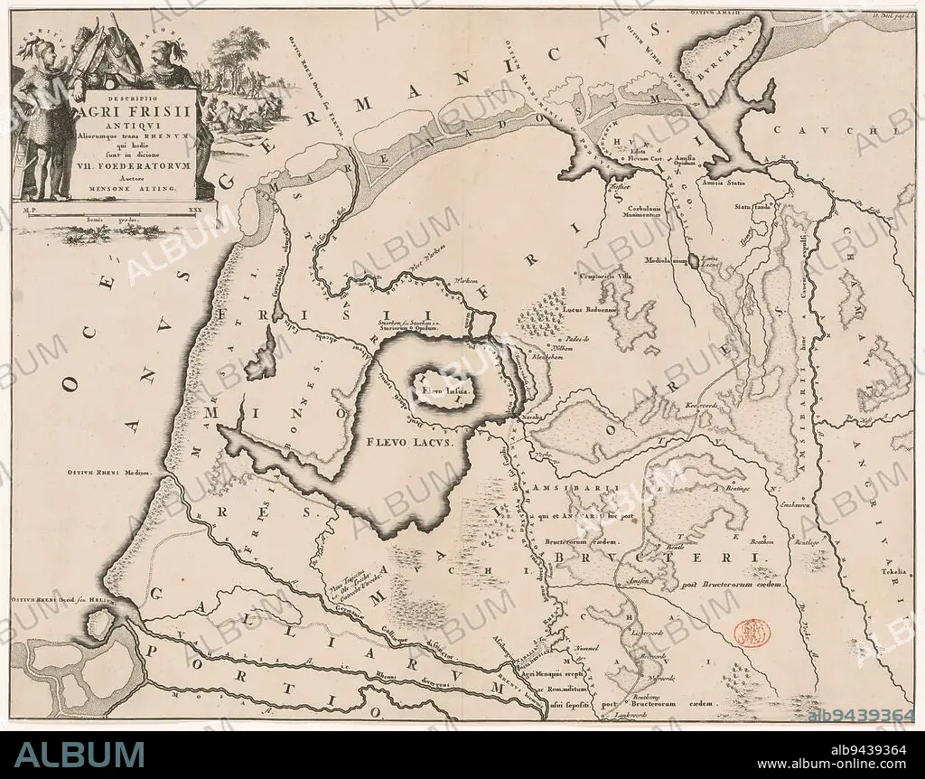
Historical map of the Netherlands with the areas of the Batavians and Frisians, Descriptio agri Frisii Antiqui (...) (title on object), Map of the Frisian areas in Roman times. Top left cartouche with title, surrounded by arms and Frisian chieftains Verritus and Malorix, depicted in the background warriors. Scale stick below cartouche: Semis gradus., print maker: Jan Luyken, Menso Alting, (mentioned on object), Netherlands, 1697 - 1700 and/or 1725, paper, engraving, etching, height 329 mm × width 420 mm.
| Share |
|---|
 Pinterest Pinterest |
 Twitter Twitter |
 Facebook Facebook |
 Copy link Copy link |
 Email Email |
|
Add to another lightbox |
|
Add to another lightbox |


Caption:
Historical map of the Netherlands with the areas of the Batavians and Frisians, Descriptio agri Frisii Antiqui (...) (title on object), Map of the Frisian areas in Roman times. Top left cartouche with title, surrounded by arms and Frisian chieftains Verritus and Malorix, depicted in the background warriors. Scale stick below cartouche: Semis gradus., print maker: Jan Luyken, Menso Alting, (mentioned on object), Netherlands, 1697 - 1700 and/or 1725, paper, engraving, etching, height 329 mm × width 420 mm
Credit:
Album / quintlox
Releases:
Model: No - Property: No
Rights questions?
Rights questions?
Image size:
3636 x 2871 px | 29.9 MB
Print size:
30.8 x 24.3 cm | 12.1 x 9.6 in (300 dpi)
Keywords:
1697 • 1700 • 1725 • AREAS • ARMS • BACKGROUND WARRIORS • BATAVIANS • CARTOUCHE • DEPICTED • DESCRIPTIO AGRI FRISII ANTIQUI • ENGRAVED • ENGRAVING (ARTWORK) • ENGRAVING • ENGRAVING. • ENGRAVINGS • ETCHING • FRISIAN AREAS • FRISIAN CHIEFTAINS VERRITUS • FRISIANS • HEIGHT 329 MM × WIDTH 420 MM • HISTORICAL MAP • JAN LUYKEN • MALORIX • MAP • MAPS • MENSO ALTING • MENTIONED • NETHERLANDS • OBJECT • OBJECTS • PAPER AND PACKAGE PRODUCTS • PAPER • PLAN (CARTOGRAPHY) • PRINT MAKER • PRINT • ROMAN TIMES • SCALE STICK • SEMIS GRADUS • SURROUNDED • TITLE • TOP LEFT CARTOUCHE • UMBRELLA
