alb5371914
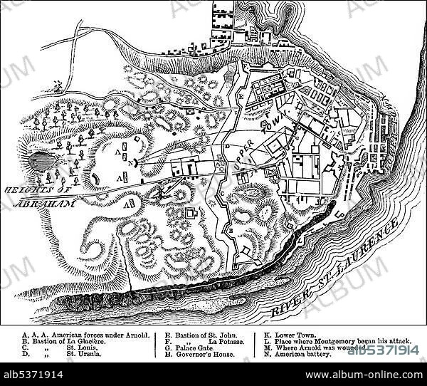
Historical drawing, US-American history, 18th century, map of the Battle of Quebec, 31st December 1775, between the British and the Americans in the Revolutionary War, near Quebec, Canada, North America.
| Share |
|---|
 Pinterest Pinterest |
 Twitter Twitter |
 Facebook Facebook |
 Copy link Copy link |
 Email Email |
|
Add to another lightbox |
|
Add to another lightbox |


Caption:
Historical drawing, US-American history, 18th century, map of the Battle of Quebec, 31st December 1775, between the British and the Americans in the Revolutionary War, near Quebec, Canada, North America
Personalities:
Credit:
Album / ImageBroker / H.-D. Falkenstein
Releases:
Model: No - Property: No
Rights questions?
Rights questions?
Image size:
600 x 509 px | 894.7 KB
Print size:
5.1 x 4.3 cm | 2.0 x 1.7 in (300 dpi)
Keywords:
1700S, THE • 18TH CENTURY • 18TH CENTURY, THE • AGE • ÂGÉS • AUS • BATTLE • BATTLES • BLACK AND WHITE • BLACK-AND-WHITE • BLACK-WHITE • CANADA • CANADIAN • CARD • CARDBOARD • CARDS • CHARTS • DECEMBER • DEPICTION • DEPICTIONS • DRAWING • DRAWINGS • EEUU • EIGHTEENTH CENTURY • HISTORIC • HISTORICAL • HISTORY • HUNDRED YEARS WAR • IMAGE MOTIF • INFORMATION • LETTERING • LETTERINGS • MAP • MAPS • NORTH AMERICA • OLD AGE • OLD • OVERVIEW • OVERVIEWS • PLAN • PLANNING • PLANNINGS • PLANS • QUEBEC CITY • QUEBEC • QUéBEC • SKETCH • UNITED STATES • WAR • WARFARES • WATERS
