alb4285312
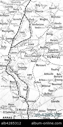
Map of the battle to the North of Arras
| Share |
|---|
 Pinterest Pinterest |
 Twitter Twitter |
 Facebook Facebook |
 Copy link Copy link |
 Email Email |
|
Add to another lightbox |
|
Add to another lightbox |


Title:
Map of the battle to the North of Arras
Caption:
First World War.. Map showing the battle ground, North of Arras. British Front: from Bassée to Liévin. . Front français: from Souchez to Roclincourt.
Credit:
Album / Photo12/Archives Snark
Releases:
Model: No - Property: No
Rights questions?
Rights questions?
Image size:
2480 x 4676 px | 33.2 MB
Print size:
21.0 x 39.6 cm | 8.3 x 15.6 in (300 dpi)
Keywords:
1ST WORLD WAR • 20TH CENTURY • ANGRES • FIRST WORLD WAR • FRANCE • GRENAY • HAISNES • HULLUCH • LENS • LOOS • MAP • NEUCITY-SAINT-VAAST • THÉLUS • WORLD WAR I (1914-18) • WORLD WAR I • WW1 • WWI
