alb3897671
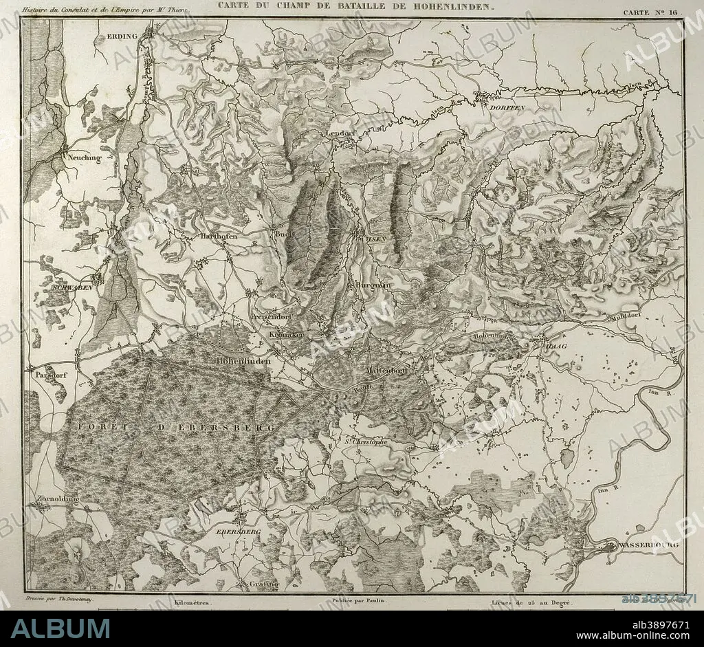
Napoleonic map. Hohenlinden battlefield map. Battle of Hohenlinden (3rd December, 1800), during the French Revolutionary Wars. Victory of the French troops, under Jean Victor Marie Moreau, against the Austrians and Bavarians led by Archduke John of Austria. Atlas de l'Histoire du Consulat et de l'Empire. History of the Consulate and the Empire of France under Napoleon by Marie Joseph Louis Adolphe Thiers (1797-1877). Drawings by Dufour and engravings by Dyonnet. Edited in Paris, 1864.
| Share |
|---|
 Pinterest Pinterest |
 Twitter Twitter |
 Facebook Facebook |
 Copy link Copy link |
 Email Email |
|
Add to another lightbox |
|
Add to another lightbox |


Caption:
Napoleonic map. Hohenlinden battlefield map. Battle of Hohenlinden (3rd December, 1800), during the French Revolutionary Wars. Victory of the French troops, under Jean Victor Marie Moreau, against the Austrians and Bavarians led by Archduke John of Austria. Atlas de l'Histoire du Consulat et de l'Empire. History of the Consulate and the Empire of France under Napoleon by Marie Joseph Louis Adolphe Thiers (1797-1877). Drawings by Dufour and engravings by Dyonnet. Edited in Paris, 1864.
Personalities:
Credit:
Album / Prisma
Releases:
Model: No - Property: No
Rights questions?
Rights questions?
Image size:
4252 x 3688 px | 44.9 MB
Print size:
36.0 x 31.2 cm | 14.2 x 12.3 in (300 dpi)
Keywords:
1800 • 1864 • 19TH CENTURY • 19TH • ADOLPHE THIERS • ANCIENT CARTOGRAPHY • ANCIENT • ANTIQUE • ARCHDUKE JOHN • ATLANTE • ATLANTEAN • ATLAS DE L'HISTOIRE DU CONSULAT ET DE L'EMPIRE • ATLAS • AUSTRIA • AUSTRIAN • AUSTRIANS • BATTLE OF HOHENLINDEN • BATTLE • BATTLEFIELD • BAVARIA (PERSONIFICATION) • BAVARIA • BAVARIANS • CARTOGRAPHY • COMBAT • CONSULATE • DECEMBER 3 • DISPUTE • DRAWING • DRAWN • DUFOUR • DYONNET • EBERSBERG • EDITION • EMPIRE • ENGRAVED • ENGRAVER • ENGRAVING (ARTWORK) • ENGRAVING • ENGRAVING. • ENGRAVINGS • ETCHING • EUROPE • EUROPEA • EUROPEAN • FIGHT • FIGHTING • FIRST FRENCH EMPIRE • FRANCE • FRANÇAIS • FRENCH EMPIRE • FRENCH REVOLUTIONARY WARS • FRENCH VICTORY • FRENCH • GEOGRAPHICAL • GEOGRAPHY • GERMANY • HISTORIA UNIVERSAL • HISTORIC • HISTORICAL • HISTORY OF THE CONSULATE AND THE EMPIRE OF FRANCE UNDER NAPOLEON • HISTORY OF THE CONSULATE AND THE NAPOLEON EMPIRE • HISTORY • HOHENLINDEN BATTLEFIELD • HOHENLINDEN • HUNDRED YEARS WAR • MAP MAKING • MAP • MARIE JOSEPH LOUIS ADOLPHE THIERS • MOREAU • NAPOLEON I • NAPOLEON'S FRENCH EMPIRE • NAPOLEON • NAPOLEONIC EMPIRE • NAPOLEONIC ERA • NAPOLEONIC MAP • NAPOLEONIC WAR • OLD • PEACE, NAPOLEONIC WARS • PLAN (CARTOGRAPHY) • PRINT • PUBLICATION • SCHWABEN • SCUFFLE • SECOND COALITION • STRUGGLE • SURFACE • SWABIA • TERRITORY • THIERS • WAR • WASSERBOURG
