alb3832196
Earth's Ecozones

|
Add to another lightbox |
|
Add to another lightbox |


Buy this image.
Select the use:

Title:
Earth's Ecozones
Caption:
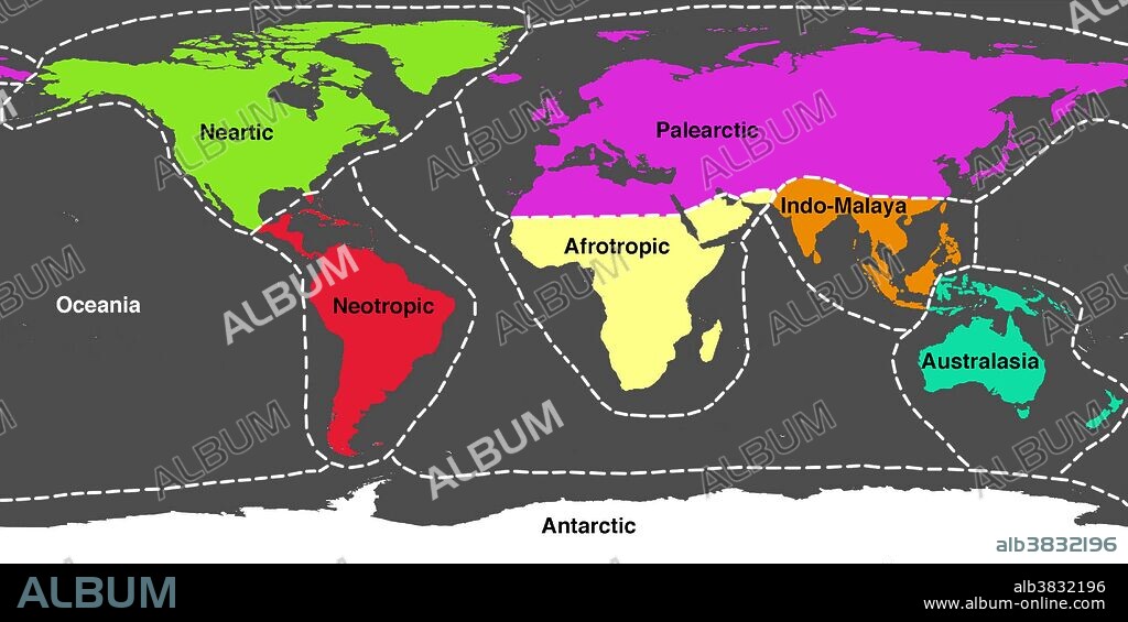
A world map showing the approximate 8 main ecozones of Earth. An ecozone is a region containing animal life that evolved together, separated from the other ecozones, for most of their history. The ecozones are: Palaearctic (purple, covering much of Eurasia); Nearctic (green, North America); Neotropic (red, South and Central America); Afrotropic (yellow, sub-Saharan Africa); Indomalaya (orange, covering South-East Asia and some equatorial Pacific islands); Australasia (blue, covering Australasia); Oceania (beige, the Pacific islands); and Antarctic (white).
Category:
Ecology & Environment
Credit:
Album / Science Source / Jessica Wilson/NASA
Releases:
Image size:
4500 x 2250 px | 29.0 MB
Print size:
38.1 x 19.1 cm | 15.0 x 7.5 in (300 dpi)
Keywords:
AFRICA • AFRICAN CONTINENT • AFRICAN • AFROTROPIC • AMERICA NORTH • ANTARCTIC • ART • ARTWORK • AUSTRALASIA • CENTRAL AMERICA • COMPUTER GRAPHIC • CONTINENT • EARTH SCIENCE • EARTH • ECOLOGY & ENVIRONMENT • ECOLOGY • ECOZONE • EURASIA • EVOLUTION • FAUNA DISTRIBUTION • GLOBAL • ILLUSTRATION • ILLUSTRATIONS • ILUSTRATION • INDOMALAYA • MAP • NEARCTIC • NEOTROPIC • NORTH AMERICA • NORTH AMERICAN • OCEANIA • PALAEARCTIC • REALM • REGION • SCIENCE: EVOLUTION • SOUTH AMERICA • SOUTH-EAST ASIA • SOUTHEAST ASIA • WILDLIFE EVOLUTION • WORLD


 Pinterest
 Twitter
 Facebook
 Copy link
 Email
Email
