alb4069688
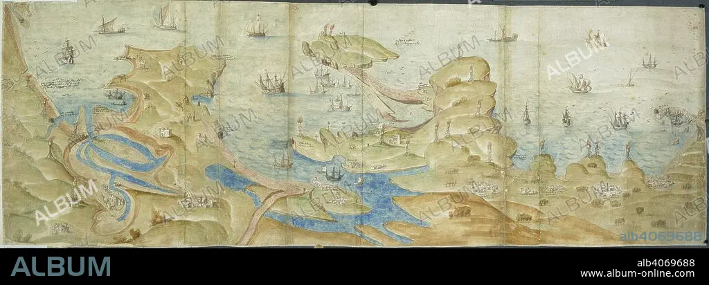
Map of Dorset coast. 1539-1540. Map of the Dorset coast from Poole to Portland and Lyme Regis, showing coastal defences, with beacons and crosses. Originally published/produced in 1539-1540. . Source: Cotton Augustus I. i. 31 and 33,.
| Share |
|---|
 Pinterest Pinterest |
 Twitter Twitter |
 Facebook Facebook |
 Copy link Copy link |
 Email Email |
|
Add to another lightbox |
|
Add to another lightbox |


Caption:
Map of Dorset coast. 1539-1540. Map of the Dorset coast from Poole to Portland and Lyme Regis, showing coastal defences, with beacons and crosses. Originally published/produced in 1539-1540. . Source: Cotton Augustus I. i. 31 and 33,.
Credit:
Album / British Library
Releases:
Model: No - Property: No
Rights questions?
Rights questions?
Image size:
6932 x 2428 px | 48.2 MB
Print size:
58.7 x 20.6 cm | 23.1 x 8.1 in (300 dpi)
Keywords:
CARTOGRAPHY • COAST • COASTAL • COASTLINE • DORSET • EUROPE • GREAT BRITAIN • LAND FEATURES • MAP MAKING • MAP • MARITIME • PLAN (CARTOGRAPHY) • POOLE • SEACOAST • SEAFRONT • SEASCAPE WITH BEACH • SEASHORE • SEASIDE • SHORELINE • TOPOGRAPHY • WESTERN EUROPE
