alb3839627
Hurricane Katrina Damage, Gulfport, MS
| Share |
|---|
 Pinterest Pinterest |
 Twitter Twitter |
 Facebook Facebook |
 Copy link Copy link |
 Email Email |
|
Add to another lightbox |
|
Add to another lightbox |


Title:
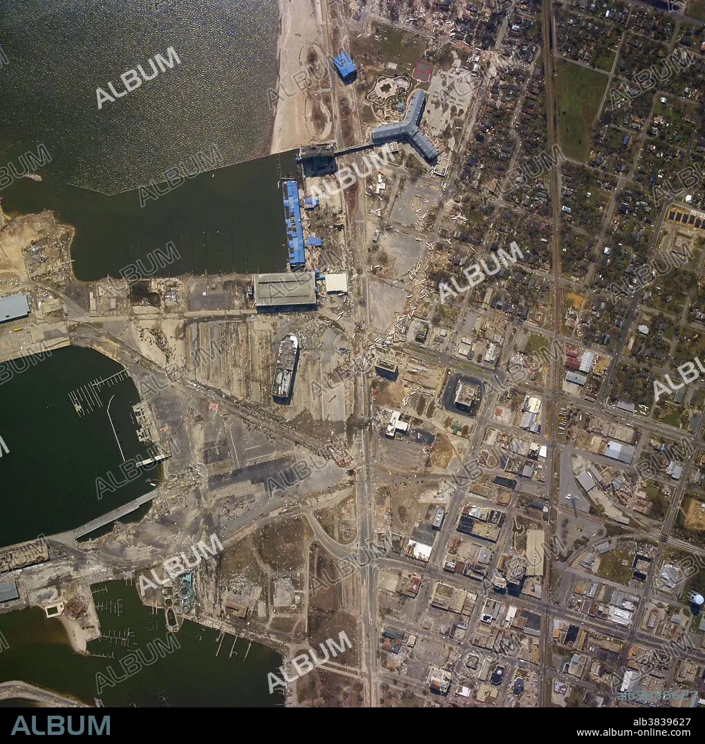
Hurricane Katrina Damage, Gulfport, MS
Caption:
Gulfport, Mississippi where the port sustained widespread destruction. NOAA used an Emerge/Applanix Digital Sensor System, or DSS, to acquire the images from an altitude of 7,500 feet. The equipment was mounted on NOAA's Cessna Citation aircraft, which is a versatile twin-engine jet aircraft modified for acquiring coastal remote sensing imagery. The aircraft can support a wide variety of remote sensing configurations, including large format aerial photography, as well as data collection for digital cameras, hyperspectral, multispectral and LIDAR systems. Hurricane Katrina was the deadliest and most destructive Atlantic tropical cyclone of the 2005 Atlantic hurricane season. It is the costliest natural disaster, as well as one of the five deadliest hurricanes, in the history of the United States. Katrina is the seventh most intense Atlantic hurricane ever recorded, part of the 2005 season that included three of the six most intense Atlantic hurricanes ever documented (along with #1 Wilma and #4 Rita). At least 1,833 people died in the hurricane and subsequent floods, making it the deadliest U.S. hurricane since the 1928 Okeechobee hurricane; total property damage was estimated at $108 billion (2005 USD).
Credit:
Album / NOAA/Science Source
Releases:
Model: No - Property: No
Rights questions?
Rights questions?
Image size:
3587 x 3600 px | 36.9 MB
Print size:
30.4 x 30.5 cm | 12.0 x 12.0 in (300 dpi)
Keywords:
2005 ATLANTIC HURRICANE SEASON • 2005 • 21ST CENTURY • 21TH CENTURY • AERIAL PHOTOGRAPHY • AERIAL • AFTERMATH • AMERICA • AMERICAN • ATLANTIC BASIN • ATLANTIC HURRICANE • ATMOSPHERIC CONDITIONS • ATMOSPHERIC • CATEGORY 5 • COSTLIEST • COSTLY • DAMAGE • DAMAGED • DEADLIEST • DEADLY • DEBRIS • DESTROYED • DESTRUCTION • DEVASTATION • DSS IMAGE • DSS • EMERGE / APPLANIX DIGITAL SENSOR SYSTEM • GULFPORT • HISTORIC • HISTORICAL • HISTORY • HURRICANE KATRINA • HURTING • INTENSE • METEOROLOGICAL • METEOROLOGY • METEOROLOGY • MISSISSIPPI • NATURAL DISASTER • NATURAL PHENOMENA • NATURAL PHENOMENON • NOAA • PHENOMENA • PHENOMENON • SCIENCE • SÉVÈRE • STORM • STRONG WEATHER • STRONGEST • TROPICAL CYCLONE • TROPICAL HURRICANE • TROPICAL STORM • UNITED STATES • US • USA • VIOLENT • WEATHER EVENT • WEATHER
