alb3799698
Map of Tenochtitlan, 1524
| Share |
|---|
 Pinterest Pinterest |
 Twitter Twitter |
 Facebook Facebook |
 Copy link Copy link |
 Email Email |
|
Add to another lightbox |
|
Add to another lightbox |


Title:
Map of Tenochtitlan, 1524
Caption:
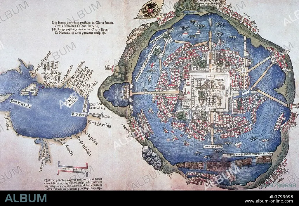
Map of Tenochtitlan, printed 1524 in Nuremberg, Germany by Friedrich Peypus, probably after drawing made by one of Cortez' men. Mexico-Tenochtitlan, commonly known as Tenochtitlan, was an Aztec altepetl (city-state) located on an island in Lake Texcoco, in the Valley of Mexico. Founded in 1325, a thriving culture developed, and the Mexica civilization came to dominate other tribes around Mexico. The small natural island was perpetually enlarged as Tenochtitlan grew to become the largest and most powerful city in Mesoamerica. The city was connected to the mainland by causeways leading to the north, south, and west. The causeways were interrupted by bridges that allowed canoes and other traffic to pass freely. The bridges could be pulled away, if necessary, to defend the city. The city was interlaced with a series of canals, so that all sections of the city could be visited either on foot or via canoe. It was captured by the Spanish in 1521. Today the ruins of Tenochtitlan are located in Mexico City's downtown.
Personalities:
Credit:
Album / Science Source
Releases:
Model: No - Property: No
Rights questions?
Rights questions?
Image size:
4650 x 2962 px | 39.4 MB
Print size:
39.4 x 25.1 cm | 15.5 x 9.9 in (300 dpi)
Keywords:
1520S • 1524 • 16 16TH XVI XVITH SIXTEENTH CENTURY • 16 CENTURY • 16TH CENTURY • 16TH • ALTEPETL • ANCIENT CIVILIZATION • ANCIENT CULTURE • ART • ARTWORK • AZTEC CIVILIZATION • AZTEC EMPIRE • AZTEC • AZTLAN • AZTLà ¡N • CAPITAL CITY • CELEBRITY • CENTRAL AMERICA • CITY-STATE • DRAWING • FAMOUS • HISTORIC • HISTORICAL • HISTORY • ILLUSTRATION • IMPORTANT • MESOAMERICA • MESOAMERICAN • MEXICO CITY • MEXICO • MEXICO-TENOCHTITLAN • MOCTEZUMA • MONTEZUMA • MOTECUHZOMA XOCOYOTZIN • MOTECUHZOMA • MOTEUCZOMA • MéXICO-TENOCHTITLAN • NAHUAS • NAHUATL • NOTABLE • PEOPLE FROM AZTLAN • SIEGE • SITE • TEMPLE • TENOCHTITLAN • WELL-KNOWN
