alb3946899
Atlantis: a map showing the location of the mythical continent, c1882 (1956). Artist: Unknown
| Share |
|---|
 Pinterest Pinterest |
 Twitter Twitter |
 Facebook Facebook |
 Copy link Copy link |
 Email Email |
|
Add to another lightbox |
|
Add to another lightbox |


Title:
Atlantis: a map showing the location of the mythical continent, c1882 (1956). Artist: Unknown
Caption:
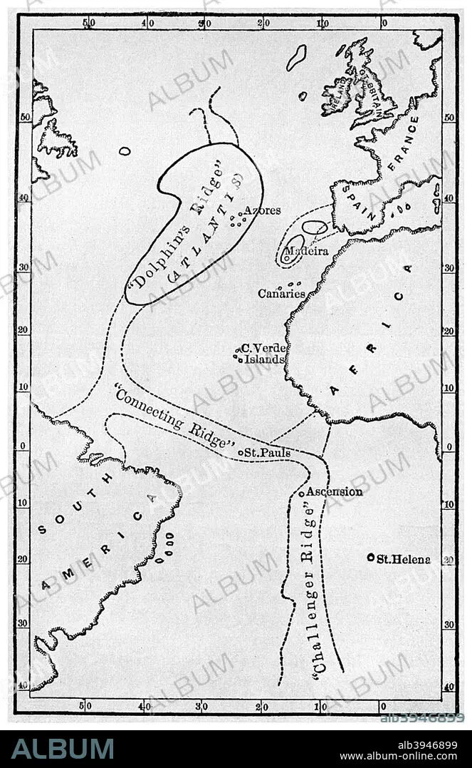
Atlantis: a map showing the location of the mythical continent, c1882 (1956). Showing its islands and connecting ridges, from deep sea soundings, from Atlantis: the Antediluvian World by Ignatius L Donnelly. Donnelly (1831-1901) was an American politician, writer and fringe scientist. His book on Atlantis, published in 1882, was a best seller, creating a mania for the idea of the legendary continent that persists to this day.
Credit:
Album / The Print Collector / Heritage Images
Releases:
Model: No - Property: No
Rights questions?
Rights questions?
Image size:
3365 x 5196 px | 50.0 MB
Print size:
28.5 x 44.0 cm | 11.2 x 17.3 in (300 dpi)
Keywords:
1 • 19TH CENTURY • ATLANTIC OCEAN • ATLANTIC • ATLANTIDA • ATLANTIS • BLACK & WHITE • BLACK AND WHITE • CARTOGRAPHY • CENTURY • CONCEPT • DONNELLY • FLEET • GEOGRAPHICAL FEATURE • GEOGRAPHY • IGNATIUS DONNELLY • IGNATIUS L DONNELLY • IGNATIUS L • IGNATIUS LOYOLA DONNELLY • LEGEND • LEGENDARY • MAP MAKING • MAP • MAP-MAKING • MARINE • MID-ATLANTIC RIDGE • MONOCHROMATIC • MONOCHROME • MYTHICAL • MYTHOLOGY • NAVY • NINETEENTH CENTURY • OCEAN • OCEAN, ATLANTIC • SEA • SEAS • THEORY
