alb3909132
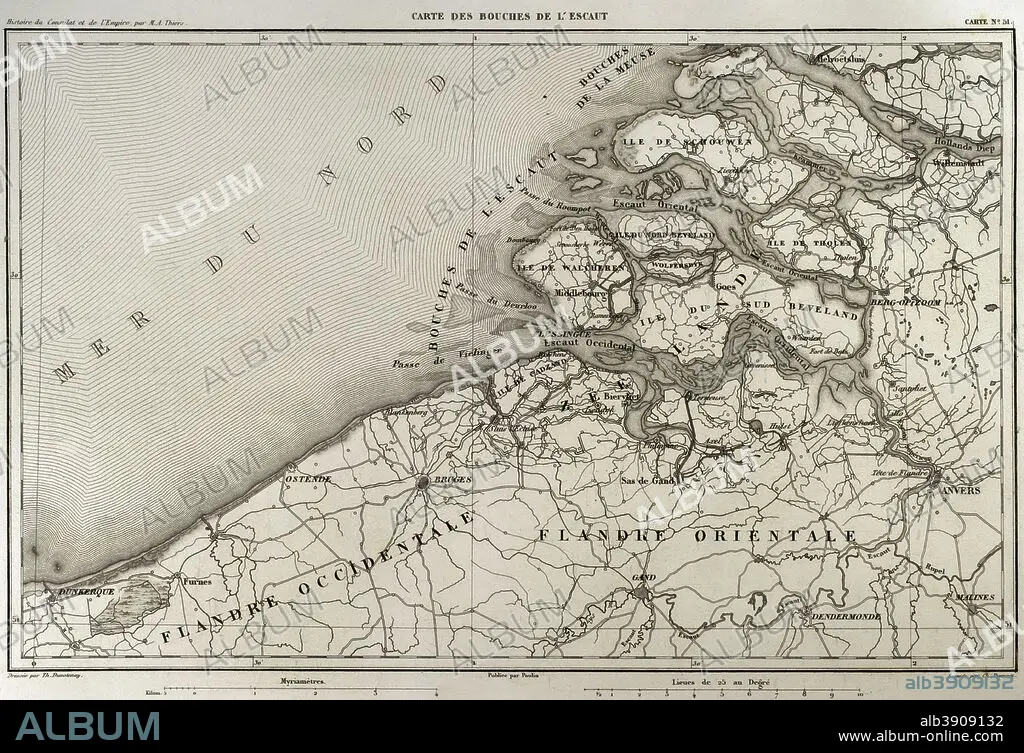
Napoleonic map. Mouth of Scheldt river (Bouches-de-L'Escaut). It was a department of the First French Empire which was formed in 1810, when the Kingdom of Holland was annexed by France. (Netherlands). Scheldt is an European river which born in France, crosses Belgium and empties into the North Sea forming an estuary. Atlas de l'Histoire du Consulat et de l'Empire. History of the Consulate and the Empire of France under Napoleon by Marie Joseph Louis Adolphe Thiers (1797-1877). Drawings by Dufour, engravings by Dyonnet. Edited in Paris, 1864.
| Share |
|---|
 Pinterest Pinterest |
 Twitter Twitter |
 Facebook Facebook |
 Copy link Copy link |
 Email Email |
|
Add to another lightbox |
|
Add to another lightbox |


Caption:
Napoleonic map. Mouth of Scheldt river (Bouches-de-L'Escaut). It was a department of the First French Empire which was formed in 1810, when the Kingdom of Holland was annexed by France. (Netherlands). Scheldt is an European river which born in France, crosses Belgium and empties into the North Sea forming an estuary. Atlas de l'Histoire du Consulat et de l'Empire. History of the Consulate and the Empire of France under Napoleon by Marie Joseph Louis Adolphe Thiers (1797-1877). Drawings by Dufour, engravings by Dyonnet. Edited in Paris, 1864.
Personalities:
Credit:
Album / Prisma
Releases:
Model: No - Property: No
Rights questions?
Rights questions?
Image size:
4940 x 3377 px | 47.7 MB
Print size:
41.8 x 28.6 cm | 16.5 x 11.3 in (300 dpi)
Keywords:
1864 • 19TH CENTURY • 19TH • ADOLPHE THIERS • ANCIENT • ANTIQUE • ANTWERP • ATLANTE • ATLANTEAN • ATLAS DE L'HISTOIRE DU CONSULAT ET DE L'EMPIRE • ATLAS DE L'HISTORIE DU CONSULAT ET DE L'EMPIRE • ATLAS • BELGIUM • BOOK • BOUCHES DE L'ESCAUT • BOUCHES-DE-L'ESCAUT • BRUGES • BRUGGE • CARTOGRAPHY • COAST • COASTAL • COASTLINE • CONSULATE, THE • COURSE • DRAWING • DRAWN • DUFOUR • DUNKERQUE • DUNKIRK • DYONNET • EAST FLANDERS • EMPIRE • ESCAUT • ESTUARY • EUROPE • EUROPEA • EUROPEAN • FIRST FRENCH EMPIRE • FLANDERS • FLEET • FLEMISH REGION • FLUVIAL • FRANCE • FRANÇAIS • FRENCH EMPIRE • FRENCH • GEOGRAPHICAL • GEOGRAPHY • GHENT • HISTORIA UNIVERSAL • HISTORIC • HISTORICAL • HISTORY OF THE CONSULATE AND THE EMPIRE OF FRANCE UNDER NAPOLEON • HISTORY OF THE CONSULATE AND THE NAPOLEON EMPIRE • HISTORY • HOLLAND • LIBRO • MAP MAKING • MAP • MAP-MAKING • MAPPING • MARIE JOSEPH LOUIS ADOLPHE THIERS • MARINE • MARITIME • MIDDELBURG • MODERN AGE • MODERN ERA • MODERN PERIOD • MOUTH • NAPOLEON I • NAPOLEON'S FRENCH EMPIRE • NAPOLEON • NAPOLEONIC EMPIRE • NAPOLEONIC MAP • NAPOLEONIC PERIOD • NAVY • NETHERLADS • NETHERLANDS • NORDEN • NORTH SEA • NORTH • OCEAN • OLD • OSTEND • OSTENDE • PLAN (CARTOGRAPHY) • PLAN • PLANE • RIVER MOUTH • RIVER • SCHELDT • SEA • SEAS • SEASHORE • SEASIDE • SHORELINE • STREAM • SURFACE • TERRITORY • THIERS • WEST FLANDERS • ZEELAND • ZEELANDIC FLANDERS
