alb6161355
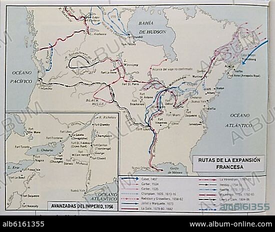
MAPA DE CANADA-RUTAS DE LA EXPANSION FRANCESA DESDE EL S XV AL XIX
| Share |
|---|
 Pinterest Pinterest |
 Twitter Twitter |
 Facebook Facebook |
 Copy link Copy link |
 Email Email |
|
Add to another lightbox |
|
Add to another lightbox |


Caption:
Automatic translation: MAP OF CANADA-ROUTES OF FRENCH EXPANSION FROM THE XV TO THE XIX CENTURY
MAPA DE CANADA-RUTAS DE LA EXPANSION FRANCESA DESDE EL S XV AL XIX
Credit:
Album / Oronoz
Releases:
Model: No - Property: No
Rights questions?
Rights questions?
Image size:
Not available
Print size:
Not available
Keywords:
15 15TH XV XVTH FIFTEENTH CENTURY • 15TH CENTURY • 15TH CENTURY; • 16 16TH XVI XVITH SIXTEENTH CENTURY • 16TH CENTURY • 17TH CENTURY • 18TH CENTURY • 18TH CENTURY, THE • 18TH • 19TH CENTURY • 19TH • ADVANCE • CATTLE DROVING • EXPANSION • FIFTEENTH CENTURY • FRANCE • FRANÇAIS • FRENCH • MAP • PLAN (CARTOGRAPHY) • ROUTE • SIGLO XV
