alb4285312
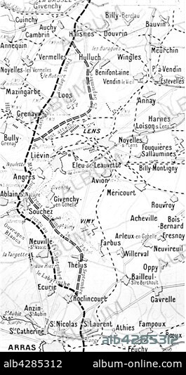
Map of the battle to the North of Arras
| Compartir |
|---|
 Pinterest Pinterest |
 Twitter Twitter |
 Facebook Facebook |
 Copiar enlace Copiar enlace |
 Email Email |
|
Añadir a otro lightbox |
|
Añadir a otro lightbox |


¿Ya tienes cuenta? Iniciar sesión
¿No tienes cuenta? Regístrate
Compra esta imagen

Título:
Map of the battle to the North of Arras
Descripción:
Ver traducción automática
First World War.. Map showing the battle ground, North of Arras. British Front: from Bassée to Liévin. . Front français: from Souchez to Roclincourt.
Crédito:
Album / Photo12/Archives Snark
Autorizaciones:
Modelo: No - Propiedad: No
¿Preguntas relacionadas con los derechos?
¿Preguntas relacionadas con los derechos?
Tamaño imagen:
2480 x 4676 px | 33.2 MB
Tamaño impresión:
21.0 x 39.6 cm | 8.3 x 15.6 in (300 dpi)
Palabras clave:
