alb5378420
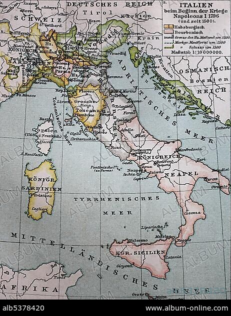
Map of Italy from 1500 to the beginning of the wars Napoleon I., 1796, historical illustration, Italy, Europe.
| Compartir |
|---|
 Pinterest Pinterest |
 Twitter Twitter |
 Facebook Facebook |
 Copiar enlace Copiar enlace |
 Email Email |
|
Añadir a otro lightbox |
|
Añadir a otro lightbox |


¿Ya tienes cuenta? Iniciar sesión
¿No tienes cuenta? Regístrate
Compra esta imagen

Descripción:
Ver traducción automática
Map of Italy from 1500 to the beginning of the wars Napoleon I., 1796, historical illustration, Italy, Europe
Crédito:
Album / ImageBroker / BAO
Autorizaciones:
Modelo: No - Propiedad: No
¿Preguntas relacionadas con los derechos?
¿Preguntas relacionadas con los derechos?
Tamaño imagen:
462 x 600 px | 812.1 KB
Tamaño impresión:
3.9 x 5.1 cm | 1.5 x 2.0 in (300 dpi)
Palabras clave:
BOCETO • CARTAS • COLOREADA • CONFLICTO BELICO • CUENTO • DIBUJO • DIBUJOS • EUROPA • FRANCES • GEOGRAFIA • GUERRA • HISTORIA CONTEMPORANEA • HISTORIA • HISTORICO • ILUSTRACION • ILUSTRADO • ITALIA • MAPA • NADIE • NAPOLEON BONAPARTE • NAPOLÉON • PERSONALIDAD • PERSONALIDADES • RELATO • SIGLO XVIII • SIN GENTE • SUR DE EUROPA • TARJETA • TARJETAS • WAR
