alb1962483
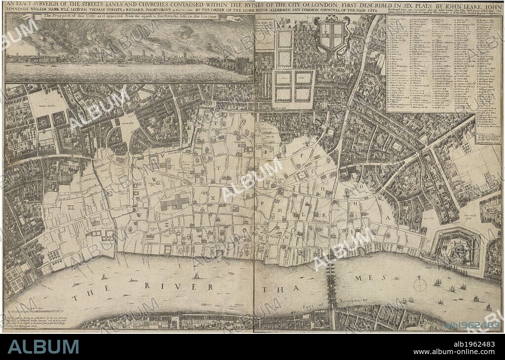
JOHN LEAKE. A map showing the ruins of the city of London, caused by the great fire of London, in 1666. AN EXACT SVRVEIGH OF THE STREETS LANES AND CHVRCHES CONTAINED WITHIN THE RVINES OF THE CITY OF LONDON : FIRST DESCRIBED IN SIX PLATS, BY IOHN LEAKE, IOHN IENNINGS, WILLIAM MARR, WILLM. LEYBVRN, THOMAS STREETE & RICHARD SHORTGAVE in Decber. Ao. 1666. BY THE ORDER OF THE LORD MAYOR ALDERMEN, AND COMMON COVNCELL OF THE SAID CITY. Reduced here into one intire plat, by Iohn Leake, the Citty Wall being added also; The places where the Halls stood, are exprest by Coats of Armes & all the Wards divided by pricks & Alphabet etc. / Wenceslaus Hollar fecit, 1667 ; Ionas Moore & Ralph Graterix Surveyors. London : Published by Nathanaell Brooke Stationer, 1667. Source: Maps Crace Port.1.50. Language: English.

|
Añadir a otro lightbox |
|
Añadir a otro lightbox |


¿Ya tienes cuenta? Iniciar sesión
¿No tienes cuenta? Regístrate
Compra esta imagen

Autor:
Descripción:
Ver traducción automática
A map showing the ruins of the city of London, caused by the great fire of London, in 1666. AN EXACT SVRVEIGH OF THE STREETS LANES AND CHVRCHES CONTAINED WITHIN THE RVINES OF THE CITY OF LONDON : FIRST DESCRIBED IN SIX PLATS, BY IOHN LEAKE, IOHN IENNINGS, WILLIAM MARR, WILLM. LEYBVRN, THOMAS STREETE & RICHARD SHORTGAVE in Decber. Ao. 1666. BY THE ORDER OF THE LORD MAYOR ALDERMEN, AND COMMON COVNCELL OF THE SAID CITY. Reduced here into one intire plat, by Iohn Leake, the Citty Wall being added also; The places where the Halls stood, are exprest by Coats of Armes & all the Wards divided by pricks & Alphabet etc. / Wenceslaus Hollar fecit, 1667 ; Ionas Moore & Ralph Graterix Surveyors. London : Published by Nathanaell Brooke Stationer, 1667. Source: Maps Crace Port.1.50. Language: English.
Crédito:
Album / British Library
Autorizaciones:
Modelo: No - Propiedad: No
¿Preguntas relacionadas con los derechos?
¿Preguntas relacionadas con los derechos?
Tamaño imagen:
6250 x 4133 px | 73.9 MB
Tamaño impresión:
52.9 x 35.0 cm | 20.8 x 13.8 in (300 dpi)
Palabras clave:
ACONTECIMIENTO • ANIVERSARIO • ANIVERSARIOS • ASENTAMIENTO • ASENTAMIENTOS • CARTOGRAFIA • CATASTROFE • CHURCH • CIUDAD • DESASTRE • EDIFICIO RELIGIOSO • ESTRUCTURA RELIGIOSA • EUROPA OCCIDENTAL • EUROPA • GRAN BRETAÑA • IGLESIA • INGLATERRA • ISLAS BRITANICAS • LEAKE, JOHN • LONDON • LONDRES • MAPA • RIO TAMESIS • SIGLO XVII • TAMESIS
 Pinterest
 Twitter
 Facebook
 Copiar enlace
 Email
Email
