alb3946899
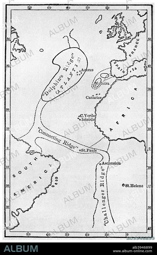
Atlantis: a map showing the location of the mythical continent, c1882 (1956). Artist: Unknown
| Compartir |
|---|
 Pinterest Pinterest |
 Twitter Twitter |
 Facebook Facebook |
 Copiar enlace Copiar enlace |
 Email Email |
|
Añadir a otro lightbox |
|
Añadir a otro lightbox |


¿Ya tienes cuenta? Iniciar sesión
¿No tienes cuenta? Regístrate
Compra esta imagen

Título:
Atlantis: a map showing the location of the mythical continent, c1882 (1956). Artist: Unknown
Descripción:
Ver traducción automática
Atlantis: a map showing the location of the mythical continent, c1882 (1956). Showing its islands and connecting ridges, from deep sea soundings, from Atlantis: the Antediluvian World by Ignatius L Donnelly. Donnelly (1831-1901) was an American politician, writer and fringe scientist. His book on Atlantis, published in 1882, was a best seller, creating a mania for the idea of the legendary continent that persists to this day.
Crédito:
Album / The Print Collector / Heritage Images
Autorizaciones:
Modelo: No - Propiedad: No
¿Preguntas relacionadas con los derechos?
¿Preguntas relacionadas con los derechos?
Tamaño imagen:
3365 x 5196 px | 50.0 MB
Tamaño impresión:
28.5 x 44.0 cm | 11.2 x 17.3 in (300 dpi)
Palabras clave:
1 • ATLANTICO • ATLANTIDA • BLANCO Y NEGRO • CARTOGRAFIA • CONCEPTO • FLOTA • GEOGRAFIA • LEGENDARIO • MAPA • MAR • MARINA • MARINE • MÍTICO • MITOLOGIA • MONOCHROME • MONOCROMO • OCEANO ATLANTICO • OCEANO • SEA • SIGLO XIX • SIGLO • TEORIA
