alb3822803
Map of Europe, 1700
| Compartir |
|---|
 Pinterest Pinterest |
 Twitter Twitter |
 Facebook Facebook |
 Copiar enlace Copiar enlace |
 Email Email |
|
Añadir a otro lightbox |
|
Añadir a otro lightbox |


¿Ya tienes cuenta? Iniciar sesión
¿No tienes cuenta? Regístrate
Compra esta imagen

Título:
Map of Europe, 1700
Descripción:
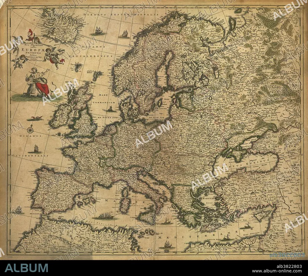
Traducción automática: Mapa de Europa del siglo XVII. Publicado en 1700, este mapa del cartógrafo holandés Federico de Witt (1630-1706) muestra los últimos conocimientos de la geografía de Europa. El mapeo ha mejorado mucho con respecto a mapas anteriores, aunque todavía hay errores y distorsiones de escala. Las inscripciones están en latín. El estandarte del título en la parte superior izquierda lo llevan querubines, y debajo hay una representación de la historia mitológica de Europa, llevada por Zeus, que tomó la forma de un toro blanco. El continente europeo lleva el nombre de Europa.
17th century map of Europe. Published in 1700, this map by the Dutch cartographer Frederick de Witt (1630-1706) shows the latest knowledge of the geography of Europe. The mapping has improved greatly on earlier maps, though there are still errors and distortions of scale. The inscriptions are in Latin. The title banner at upper left is being carried by cherubs, and below that is a depiction of the mythological tale of Europa, carried away by Zeus who took the form of a white bull. The continent of Europe is named after Europa.
Crédito:
Album / Science Source / LOC/Geography and Map Division
Autorizaciones:
Modelo: No - Propiedad: No
¿Preguntas relacionadas con los derechos?
¿Preguntas relacionadas con los derechos?
Tamaño imagen:
7024 x 5936 px | 119.3 MB
Tamaño impresión:
59.5 x 50.3 cm | 23.4 x 19.8 in (300 dpi)
Palabras clave:
CARTOGRAFIA • COLONIA (TERRITORIO) • COLONIALISMO • DE WIT • EDAD MEDIA • ESPANOL • EUROPA • EUROPEO • EXPLORACION • FRANCES • GEOGRAFIA • GEOGRAFICO • HISTORIA • HISTORICO • HOLANDES • HORIZONTAL • IMPERIO • MAPA • MEDIEVAL • MITOLOGIA GRIEGA • SIGLO XVII • SIGLO XVIII • TORO
