alb3828291
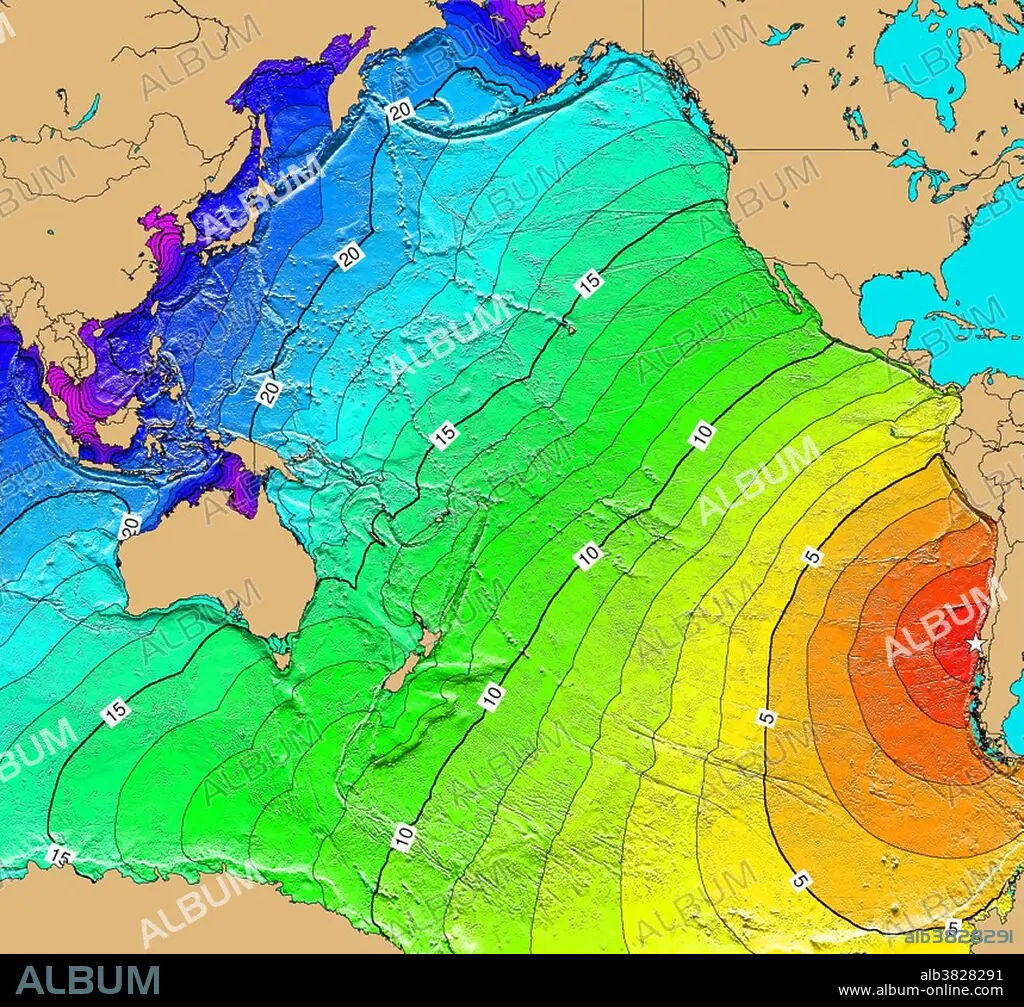
Tsunami Map, Chile Earthquake, 1960
| Partager |
|---|
 Pinterest Pinterest |
 Twitter Twitter |
 Facebook Facebook |
 Copier le lien Copier le lien |
 Email Email |
|
Ajouter à une autre Lightbox |
|
Ajouter à une autre Lightbox |


Avez-vous déjà un compte? S'identifier
Vous n'avez pas de compte ? S'inscrire
Acheter cette image

Titre:
Tsunami Map, Chile Earthquake, 1960
Légende:
Voir la traduction automatique
On May 22, 1960 a Magnitude 9.5 Mw earthquake, the largest earthquake ever instrumentally recorded, occurred in southern Chile. The series of earthquakes that followed ravaged southern Chile and ruptured over a period of days a 1,000 km section of the fault. The number of fatalities associated with both the earthquake and tsunami has been estimated to be between 490 and 5,700. Reportedly there were 3,000 injured and initially there were 717 missing in Chile. The main shock generated a tsunami that was not only destructive along the coast of Chile, but also caused numerous casualties and property damage in Hawaii and Japan, and was noticeable along shorelines throughout the Pacific Ocean area. Map generated using Tsunami Travel Time (TTT) software: calculates first-arrival travel times on a grid for a tsunami generated at an earthquake epicenter. Map contours: 1 hour intervals: red 1-4 hour arrival times, yellow: 5-6 hour arrival times, green: 7-14 hour arrival times, blue: 15-21 hour arrival times. Maps were generated from earthquake epicenters in the NGDC Global Historical Tsunami Database using NGDC 2 Minute Gridded Global Relief Data bathymetry. Maps do not provide the height or the strength of the wave, only the arrival times.
Crédit:
Album / NOAA/Science Source
Autorisations:
Modèle: Non - Propriété: Non
Questions sur les droits?
Questions sur les droits?
Taille de l'image:
3900 x 3632 px | 40.5 MB
Taille d'impression:
33.0 x 30.8 cm | 13.0 x 12.1 in (300 dpi)
Mots clés:
AMERIQUE LATINE (AMERIQUE DU SUD) • AMERIQUE LATINE • ANNEES 1960 • ANNÉES 60 • ANNEES SOIXANTE • CARTE • CÉLÈBRE • CELEBRITE • ÉVÉNEMENT • GEOLOGIE • HYDROGRAPHIE • MER • OCEAN • PAYSAGE MARITIME • SUD AMERICAIN • TECHNOLOGIE • TSUNAMI • XXE SIECLE
