alb3453969
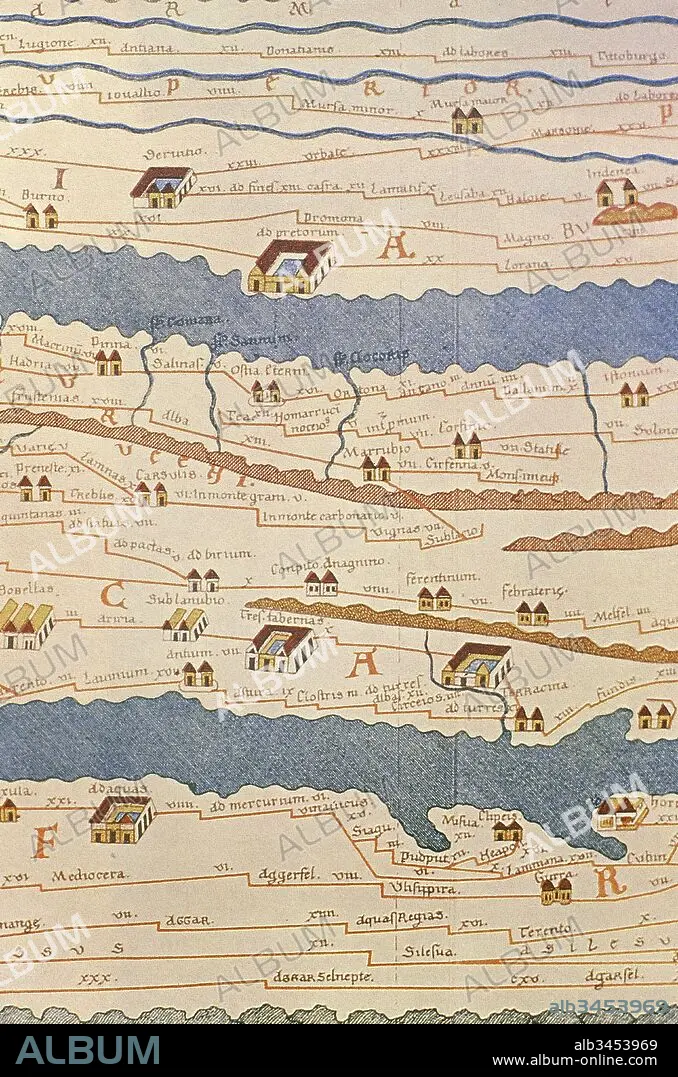
Tabula Peutingeriana or Peutinger Table. An illustrated itinerarium (ancient Roman road map) showing the layout of the road network of the Roman Empire. Painted on parchment, it is a medieval copy (13th century) of an original map of the 4th century. Detail of Italy. National Library of Vienna. Austria.
| Partager |
|---|
 Pinterest Pinterest |
 Twitter Twitter |
 Facebook Facebook |
 Copier le lien Copier le lien |
 Email Email |
|
Ajouter à une autre Lightbox |
|
Ajouter à une autre Lightbox |


Avez-vous déjà un compte? S'identifier
Vous n'avez pas de compte ? S'inscrire
Acheter cette image

Légende:
Voir la traduction automatique
Tabula Peutingeriana or Peutinger Table. An illustrated itinerarium (ancient Roman road map) showing the layout of the road network of the Roman Empire. Painted on parchment, it is a medieval copy (13th century) of an original map of the 4th century. Detail of Italy. National Library of Vienna. Austria.
Crédit:
Album / Prisma
Autorisations:
Modèle: Non - Propriété: Non
Questions sur les droits?
Questions sur les droits?
Taille de l'image:
3712 x 5610 px | 59.6 MB
Taille d'impression:
31.4 x 47.5 cm | 12.4 x 18.7 in (300 dpi)
Mots clés:
13E SIECLE • 13EME S • 4E SIECLE • 4EME S • ART ROMAIN • CARTE (GEOGRAPHIE) • CARTE GEOGRAPHIQUE • CARTE • CARTOGRAPHIE • COPIE • DESSIN PLANS • ECRITURE PARCHEMINS • ECRITURE ROULEAU • EMPIRE ROMAIN • EPOQUE ROMAINE • HISOIRE • HISTOIRE • PARCHEMIN • PARCHEMINS • PERIODE: ROME IMPERIALE • PLAN (CARTOGRAPHIE) • PLANS • POULIE • ROMAIN • ROME • ROME, IMPERIALE • ROULEAU (MANUSCRIT) • ROULEAU D'ECRITURE • ROULEAU • ROULEAUX • SCIENCE: CARTOGRAPHIE • TREIZIÈME SIÈCLE • XIIIE SIECLE
