alb1474307
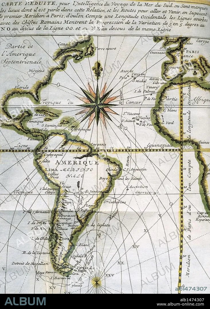
Map of the Atlantic Ocean from Newfoundland to Cape Horn. At A Voyage to the South-sea and along the coasts of Chili and Peru, in the years 1712, 1713 and 1714 by Amedee-Franc_ois Frezier (1682-1773). Published in Paris, 1716. Library of Catalonia. Barcelona. Spain.
| Partager |
|---|
 Pinterest Pinterest |
 Twitter Twitter |
 Facebook Facebook |
 Copier le lien Copier le lien |
 Email Email |
|
Ajouter à une autre Lightbox |
|
Ajouter à une autre Lightbox |


Avez-vous déjà un compte? S'identifier
Vous n'avez pas de compte ? S'inscrire
Acheter cette image

Légende:
Voir la traduction automatique
Map of the Atlantic Ocean from Newfoundland to Cape Horn. At A Voyage to the South-sea and along the coasts of Chili and Peru, in the years 1712, 1713 and 1714 by Amedee-Franc_ois Frezier (1682-1773). Published in Paris, 1716. Library of Catalonia. Barcelona. Spain.
Crédit:
Album / Kurwenal / Prisma
Autorisations:
Modèle: Non - Propriété: Non
Questions sur les droits?
Questions sur les droits?
Taille de l'image:
4466 x 6239 px | 79.7 MB
Taille d'impression:
37.8 x 52.8 cm | 14.9 x 20.8 in (300 dpi)
Mots clés:
18 18E 18EME XVIII XVIIIE XVIIIEME SIECLE • 18E SIECLE • 18EME S • AFRICAIN • AFRICAINE • AFRIQUE • AMÉRCAIN • AMÉRICAIN • AMÉRICAINE • AMÉRICIAN • AMÉRICIANE • AMÉRIQUE DU SUD • AMERIQUE • AMERIQUE, CONTINENT • BARCELONE • CANADA • CARTE (GEOGRAPHIE) • CARTE GEOGRAPHIQUE • CARTE • CARTOGRAPHIE • CATALOGNE • CONTINENT AMERIQUE • CONTINENT • CÔTE • DESSIN PLANS • DESSIN • DESSINER • DIX-HUITIÈME SIÈCLE • EUROPE • EUROPÉEN • FANCE • FRANCE • FRANÇAISE • GEOGRAPHIE: MERIDIENS • HISOIRE • HISTOIRE • ILE • ÎLES • ITALIE • LITTORAL • MARITIME • MER • MÉRIDIEN • MERIDIENS • MOTIF • OCEAN ATLANTIQUE • OCEAN • PARIS • PARIS, FRANCE • PAYSAGE MARITIME • PIMENT ROUGE • PLAN (CARTOGRAPHIE) • PLANS • SCIENCE: CARTOGRAPHIE • SUD AMERICAIN • TECHNIQUE: DESSIN • TRANSPORT VOYAGE • TRAVERSÉE • VOYAGE • XVIIIE SIECLE
