alb4076471
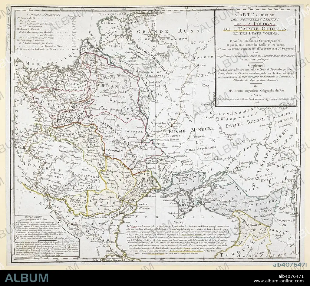
An 18th century map covering Russia; Ukraine; Poland (after the first partition); Lithuania; Tartary; Transylvania; Turkey; Hungary and surrounding territories. . Carte curieuse des nouvelles limites de la Pologne, de l'Empire Ottoman, et des EÌtats voisins, par M. Brion. 1775. Source: Maps.K.Top.110.53. Language: French.
| Partager |
|---|
 Pinterest Pinterest |
 Twitter Twitter |
 Facebook Facebook |
 Copier le lien Copier le lien |
 Email Email |
|
Ajouter à une autre Lightbox |
|
Ajouter à une autre Lightbox |


Avez-vous déjà un compte? S'identifier
Vous n'avez pas de compte ? S'inscrire
Acheter cette image.
Sélectionnez l'usage:

Légende: Voir la traduction automatique
An 18th century map covering Russia; Ukraine; Poland (after the first partition); Lithuania; Tartary; Transylvania; Turkey; Hungary and surrounding territories. . Carte curieuse des nouvelles limites de la Pologne, de l'Empire Ottoman, et des EÌtats voisins, par M. Brion. 1775. Source: Maps.K.Top.110.53. Language: French.
An 18th century map covering Russia; Ukraine; Poland (after the first partition); Lithuania; Tartary; Transylvania; Turkey; Hungary and surrounding territories. . Carte curieuse des nouvelles limites de la Pologne, de l'Empire Ottoman, et des EÌtats voisins, par M. Brion. 1775. Source: Maps.K.Top.110.53. Language: French.
Crédit: Album / British Library
Autorisations: ? Autorisation de modèle: Non - ? Autorisation de propriété: Non
Questions sur les droits?
Questions sur les droits?
Taille de l'image: 5901 × 5138 px | 86.7 MB
Taille d'impression: 50.0 × 43.5 cm | 2323.2 × 2022.8 in (300 dpi)
Mots clés: 18 18E 18EME XVIII XVIIIE XVIIIEME SIECLE • 18E SIECLE • 18EME S • CARTE (GEOGRAPHIE) • CARTE GEOGRAPHIQUE • CARTE • CARTOGRAPHIE • COULEUR • COULEURS • DESSIN PLANS • DIX-HUITIÈME SIÈCLE • EUROPE • HONGRIE • LITUANIE • PLAN (CARTOGRAPHIE) • PLANS • POLOGNE • ROUMANIE • RUSSIE • SCIENCE: CARTOGRAPHIE • TURQUIE • UKRAINE • XVIIIE SIECLE • XXE SIECLE
