alb3824286
Ancash Earthquake, Peru, 1970
| Partager |
|---|
 Pinterest Pinterest |
 Twitter Twitter |
 Facebook Facebook |
 Copier le lien Copier le lien |
 Email Email |
|
Ajouter à une autre Lightbox |
|
Ajouter à une autre Lightbox |


Avez-vous déjà un compte? S'identifier
Vous n'avez pas de compte ? S'inscrire
Acheter cette image

Titre:
Ancash Earthquake, Peru, 1970
Légende:
Voir la traduction automatique
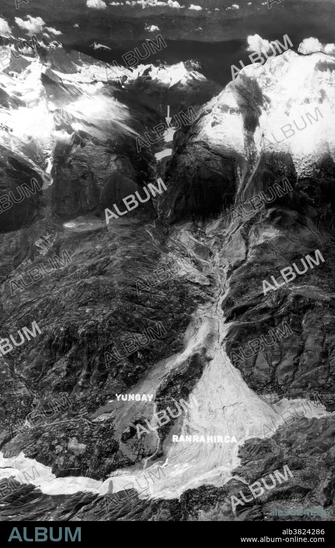
Peru Earthquake May 31, 1970. Nevados Huascaran and the Huascaran debris avalanche that destroyed Yungay and Ranrahira. The 1970 Ancash earthquake or Great Peruvian Earthquake was an undersea earthquake. Combined with a resultant landslide, it was the worst catastrophic natural disaster ever recorded in the history of Peru. The earthquake affected the Peruvian regions of Ancash and La Libertad. The epicenter of the earthquake was located 35 km off the coast of Casma and Chimbote on the Pacific Ocean, where the Nazca Plate is being subducted by the South American Plate. It had a magnitude of 7.9 to 8.0 on the Richter scale and an intensity of up to VIII on the Mercalli scale. No significant tsunami was reported. The earthquake struck on a Sunday afternoon at 15:23:31 local time (20:23:31 UTC) and lasted 45 seconds. The quake destabilized the northern wall of Mount Huascarán, causing a rock, ice and snow avalanche and burying the towns of Yungay and Ranrahirca. Five days after the earthquake, Peruvian officials feared a death toll as high as 30,000. Several days later that figure was tentatively raised to 50,000. An Associated Press dispatch on July 14 said Peru's Minister of Health now estimated the number of dead and missing persons to be 70,000. It may be impossible ever to assess fully the toll of this seismic disaster.
Crédit:
Album / USGS/Science Source
Autorisations:
Modèle: Non - Propriété: Non
Questions sur les droits?
Questions sur les droits?
Taille de l'image:
3300 x 5126 px | 48.4 MB
Taille d'impression:
27.9 x 43.4 cm | 11.0 x 17.1 in (300 dpi)
Mots clés:
