alb3808755
Ancash Earthquake, Peru, 1970
| Partager |
|---|
 Pinterest Pinterest |
 Twitter Twitter |
 Facebook Facebook |
 Copier le lien Copier le lien |
 Email Email |
|
Ajouter à une autre Lightbox |
|
Ajouter à une autre Lightbox |


Avez-vous déjà un compte? S'identifier
Vous n'avez pas de compte ? S'inscrire
Acheter cette image

Titre:
Ancash Earthquake, Peru, 1970
Légende:
Voir la traduction automatique
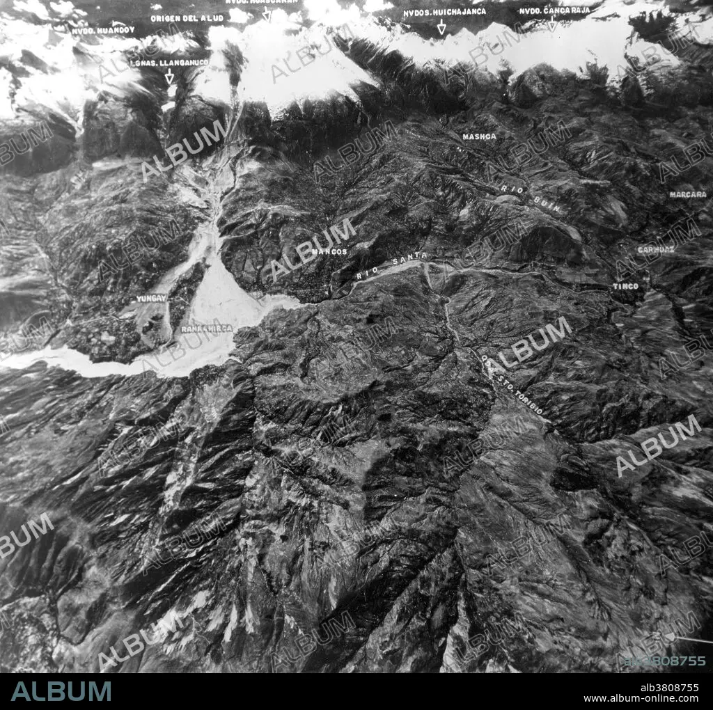
Aerial view showing mountain range including Nevada Huascaran, highest peak in Peru. Massive avalanche of ice and rock debris, triggered on North Peak by May 31, 1970 earthquake, buried towns of Yungay and Ranrahirca, killing more than 20,000 people. Avalanche started with sliding of mass of glacial ice and rock about 3,000 feet wide and one mile long that swept downslope about nine miles to Yungay at average speed of over 100 miles an hour. The 1970 Ancash earthquake was an undersea earthquake. Combined with a resultant landslide, it was the worst catastrophic natural disaster ever recorded in the history of Peru. The earthquake affected the Peruvian regions of Ancash and La Libertad. The epicenter of the earthquake was located 35 km off the coast of Casma and Chimbote on the Pacific Ocean, where the Nazca Plate is being subducted by the South American Plate. It had a magnitude of 7.9 to 8.0 on the Richter scale and an intensity of up to VIII on the Mercalli scale. No significant tsunami was reported. The earthquake struck on a Sunday afternoon at 15:23:31 local time (20:23:31 UTC) and lasted 45 seconds.
Crédit:
Album / Science Source / USGS
Autorisations:
Modèle: Non - Propriété: Non
Questions sur les droits?
Questions sur les droits?
Taille de l'image:
4500 x 4248 px | 54.7 MB
Taille d'impression:
38.1 x 36.0 cm | 15.0 x 14.2 in (300 dpi)
Mots clés:
