alb5371914
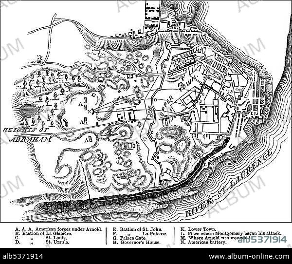
Historical drawing, US-American history, 18th century, map of the Battle of Quebec, 31st December 1775, between the British and the Americans in the Revolutionary War, near Quebec, Canada, North America.
| Partager |
|---|
 Pinterest Pinterest |
 Twitter Twitter |
 Facebook Facebook |
 Copier le lien Copier le lien |
 Email Email |
|
Ajouter à une autre Lightbox |
|
Ajouter à une autre Lightbox |


Avez-vous déjà un compte? S'identifier
Vous n'avez pas de compte ? S'inscrire
Acheter cette image

Légende:
Voir la traduction automatique
Historical drawing, US-American history, 18th century, map of the Battle of Quebec, 31st December 1775, between the British and the Americans in the Revolutionary War, near Quebec, Canada, North America
Personnalités:
Crédit:
Album / ImageBroker / H.-D. Falkenstein
Autorisations:
Modèle: Non - Propriété: Non
Questions sur les droits?
Questions sur les droits?
Taille de l'image:
600 x 509 px | 894.7 KB
Taille d'impression:
5.1 x 4.3 cm | 2.0 x 1.7 in (300 dpi)
Mots clés:
18 18E 18EME XVIII XVIIIE XVIIIEME SIECLE • 18E SIECLE • 18EME S • AMERICAIN (ETATS-UNIS) • AMERICAIN (USA) • CANADA • CARTE • CARTES • CARTON • DÉCEMBRE • DIX-HUITIÈME SIÈCLE • ÉTAS UNIS • ÉTAS-UNIS • ETATS UNIS • ETATS-UNIS • GUERRE • PLAN • U. S. A. • XVIIIE SIECLE • ŽTATS-UNIS
