alb1651927
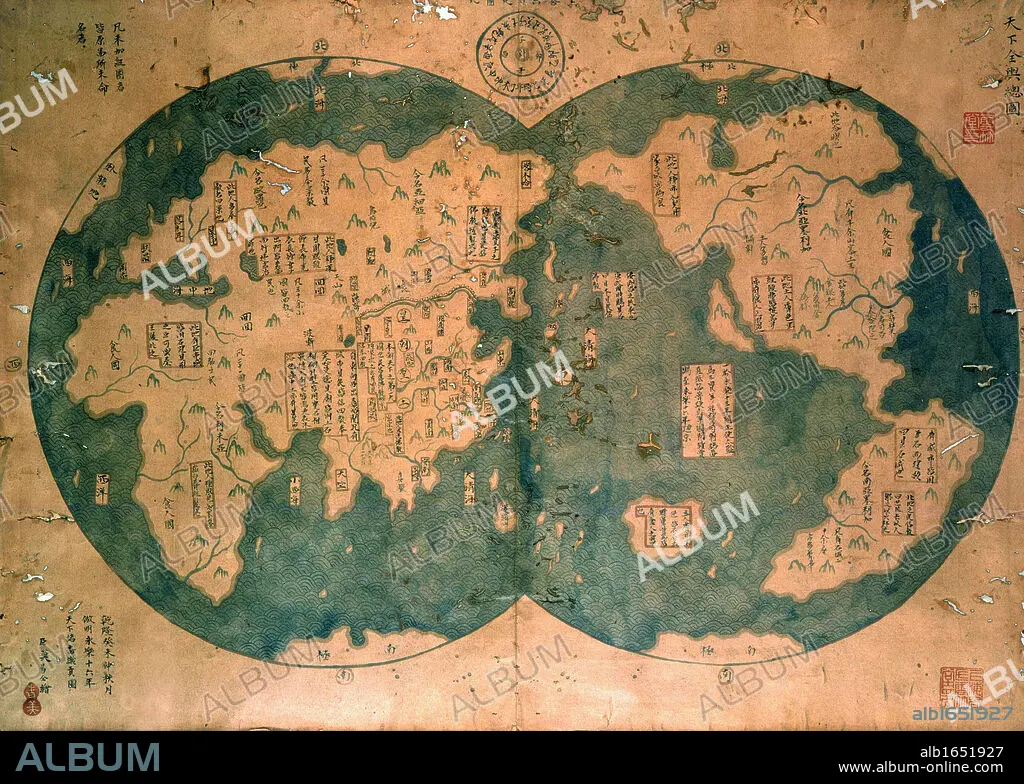
Chinese map of the world dated 1763, claiming to be a reproduction of a 1418 map of Zheng He's (1371-1433) voyages and to prove that Zheng He sailed both to Australia and the Americas. Many think the map is more likely to be based on 18th century European maps. Discovered by Lui Gang in 2005.
| Partager |
|---|
 Pinterest Pinterest |
 Twitter Twitter |
 Facebook Facebook |
 Copier le lien Copier le lien |
 Email Email |
|
Ajouter à une autre Lightbox |
|
Ajouter à une autre Lightbox |


Avez-vous déjà un compte? S'identifier
Vous n'avez pas de compte ? S'inscrire
Acheter cette image.
Sélectionnez l'usage:

Légende: Voir la traduction automatique
Chinese map of the world dated 1763, claiming to be a reproduction of a 1418 map of Zheng He's (1371-1433) voyages and to prove that Zheng He sailed both to Australia and the Americas. Many think the map is more likely to be based on 18th century European maps. Discovered by Lui Gang in 2005.
Chinese map of the world dated 1763, claiming to be a reproduction of a 1418 map of Zheng He's (1371-1433) voyages and to prove that Zheng He sailed both to Australia and the Americas. Many think the map is more likely to be based on 18th century European maps. Discovered by Lui Gang in 2005.
Crédit: Album / Universal Images Group / Universal History Archive
Autorisations: ? Autorisation de modèle: Non - ? Autorisation de propriété: Non
Questions sur les droits?
Questions sur les droits?
Taille de l'image: 3533 × 2523 px | 25.5 MB
Taille d'impression: 29.9 × 21.4 cm | 1390.9 × 993.3 in (300 dpi)
Mots clés: 15 15E 15EME XV XVE XVEME SIECLE • 15E SIECLE • 15EME S • 18 18E 18EME XVIII XVIIIE XVIIIEME SIECLE • 18E SIECLE • 18EME S • AMERIQUE • AMERIQUE, CONTINENT • AUSTRALIE • CARTE (GEOGRAPHIE) • CARTE GEOGRAPHIQUE • CARTE • CARTOGRAPHIE • CHINOIS • CHINOISE • CONTINENT AMERIQUE • DÉCOUVERTE • DESSIN PLANS • DIX-HUITIÈME SIÈCLE • EUROPÉEN • EXPLORATION • GEOGRAPHIE • MONDE • PLAN (CARTOGRAPHIE) • PLANS • QUINZIÈME SIÈCLE • REPRODUCTION • SCIENCE: CARTOGRAPHIE • XVE SIECLE • XVIIIE SIECLE
