alb4069688
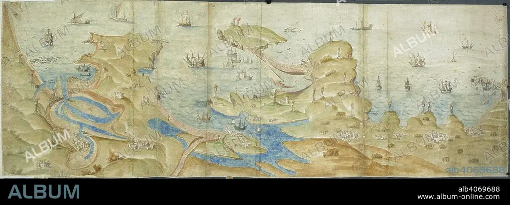
Map of Dorset coast. 1539-1540. Map of the Dorset coast from Poole to Portland and Lyme Regis, showing coastal defences, with beacons and crosses. Originally published/produced in 1539-1540. . Source: Cotton Augustus I. i. 31 and 33,.
| Partager |
|---|
 Pinterest Pinterest |
 Twitter Twitter |
 Facebook Facebook |
 Copier le lien Copier le lien |
 Email Email |
|
Ajouter à une autre Lightbox |
|
Ajouter à une autre Lightbox |


Avez-vous déjà un compte? S'identifier
Vous n'avez pas de compte ? S'inscrire
Acheter cette image

Légende:
Voir la traduction automatique
Map of Dorset coast. 1539-1540. Map of the Dorset coast from Poole to Portland and Lyme Regis, showing coastal defences, with beacons and crosses. Originally published/produced in 1539-1540. . Source: Cotton Augustus I. i. 31 and 33,.
Crédit:
Album / British Library
Autorisations:
Modèle: Non - Propriété: Non
Questions sur les droits?
Questions sur les droits?
Taille de l'image:
6932 x 2428 px | 48.2 MB
Taille d'impression:
58.7 x 20.6 cm | 23.1 x 8.1 in (300 dpi)
Mots clés:
ANGLETARRE • ANGLETERE • ANGLETERRE • CARTE (GEOGRAPHIE) • CARTE GEOGRAPHIQUE • CARTE • CARTOGRAPHIE • CÔTE • DESSIN PLANS • EUROPE • GRANDE BERTAGNE • GRANDE BRETAGNE • GRANDE-BRETAGNE • INGLATERRA • LITTORAL • MARITIME • PAYSAGE MARITIME AV. PLAGE • PLAN (CARTOGRAPHIE) • PLANS • ROYAUME UNI • ROYAUME-UNI • SCIENCE: CARTOGRAPHIE • TOPOGRAPHIE
