alb4859291
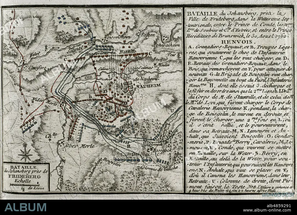
JEAN DE BEAURAIN (1696-1771). FRENCH GEOGRAPHER.. Seven Years War (1756-1763). Map of the Battle of Johannisberg, 1762 (August 30, 1762). French forces led by Louis Joseph, Prince of Conde, defeated Hanoverian and British army under the command of Duke Ferdinand of Brunswick. Published in 1765 by the cartographer Jean de Beaurain (1696-1771) as an illustration of his Great Map of Germany, with the events that took place during the Seven Years War. Allied army in red and the French army in blue. Etching and engraving. French edition, 1765. Military Historical Library of Barcelona (Biblioteca Histórico Militar de Barcelona). Catalonia. Spain.
| Partager |
|---|
 Pinterest Pinterest |
 Twitter Twitter |
 Facebook Facebook |
 Copier le lien Copier le lien |
 Email Email |
|
Ajouter à une autre Lightbox |
|
Ajouter à une autre Lightbox |


Avez-vous déjà un compte? S'identifier
Vous n'avez pas de compte ? S'inscrire
Acheter cette image

Légende:
Voir la traduction automatique
Seven Years War (1756-1763). Map of the Battle of Johannisberg, 1762 (August 30, 1762). French forces led by Louis Joseph, Prince of Conde, defeated Hanoverian and British army under the command of Duke Ferdinand of Brunswick. Published in 1765 by the cartographer Jean de Beaurain (1696-1771) as an illustration of his Great Map of Germany, with the events that took place during the Seven Years War. Allied army in red and the French army in blue. Etching and engraving. French edition, 1765. Military Historical Library of Barcelona (Biblioteca Histórico Militar de Barcelona). Catalonia. Spain.
Emplacement:
Historical Military Library of Barcelona. Catalonia. Spain.
Crédit:
Album / Prisma
Autorisations:
Modèle: Non - Propriété: Non
Questions sur les droits?
Questions sur les droits?
Taille de l'image:
4669 x 3148 px | 42.1 MB
Taille d'impression:
39.5 x 26.7 cm | 15.6 x 10.5 in (300 dpi)
Mots clés:
18 18E 18EME XVIII XVIIIE XVIIIEME SIECLE • 18E SIECLE • 18EME S • ALLEMAGNE • ANGLETERRE, HISTOIRE • BATAILLE • BATALLE • CARTE (GEOGRAPHIE) • CARTE GEOGRAPHIQUE • CARTE • CARTOGRAPHIE • CHAMP BATAILLE • CHAMP DE BATAILLE • COLONIALISME • CONFLICTS • CONFLIT • DESSIN PLANS • DIX-HUITIÈME SIÈCLE • EUROPE • EUROPÉEN • FANCE • FRANCE • FRANCE, HISTOIRE • FRANÇAISE • FRAVURE • GRAVURE • GUERRE COLONIALE • GUERRE DE SEPT ANS • GUERRE • HESSE • HISOIRE • HISTOIRE ANGLETERRE • HISTOIRE FRANCE • HISTOIRE • HISTORICAL MILITARY LIBRARY OF BARCELONA. CATALONIA. SPAIN. • JEAN DE BEAURAIN (1696-1771). FRENCH GEOGRAPHER. • JOHANNISBERG • PLAN (CARTOGRAPHIE) • PLANS • PRINCE DE CONDÉ • SCIENCE: CARTOGRAPHIE • STRATEGIE • XVIIIE SIECLE
