alb9871568
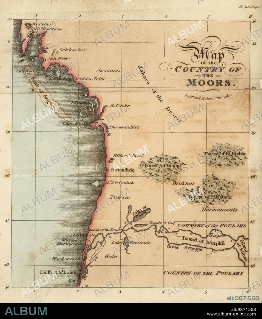
Map of Senegal and Mauritania, West Africa, 18th century. From St. Louis (Senegal) to the Bay of Arguin (Mauritania). Region of the Assounas, Poulahs, and other peoples. Map of the country of the Moors.After Rene Claude Geoffroy de Villeneuves LAfrique, Paris, 1814. Handcoloured stipple copperplate engraving from Frederic Shoberls The World in Miniature: Africa, A description of the manners and customs Moors of the Sahara and of the Negro Nations, R. Ackermann, England, 1821.
| Partager |
|---|
 Pinterest Pinterest |
 Twitter Twitter |
 Facebook Facebook |
 Copier le lien Copier le lien |
 Email Email |
|
Ajouter à une autre Lightbox |
|
Ajouter à une autre Lightbox |


Avez-vous déjà un compte? S'identifier
Vous n'avez pas de compte ? S'inscrire
Acheter cette image

Légende:
Voir la traduction automatique
Map of Senegal and Mauritania, West Africa, 18th century. From St. Louis (Senegal) to the Bay of Arguin (Mauritania). Region of the Assounas, Poulahs, and other peoples. Map of the country of the Moors.After Rene Claude Geoffroy de Villeneuves LAfrique, Paris, 1814. Handcoloured stipple copperplate engraving from Frederic Shoberls The World in Miniature: Africa, A description of the manners and customs Moors of the Sahara and of the Negro Nations, R. Ackermann, England, 1821.
Crédit:
Album / Florilegius
Autorisations:
Modèle: Non - Propriété: Non
Questions sur les droits?
Questions sur les droits?
Taille de l'image:
5501 x 6359 px | 100.1 MB
Taille d'impression:
46.6 x 53.8 cm | 18.3 x 21.2 in (300 dpi)
Mots clés:
18 18E 18EME XVIII XVIIIE XVIIIEME SIECLE • 18E SIECLE • 18EME S • AFRIQUE • CARTE (GEOGRAPHIE) • CARTE GEOGRAPHIQUE • CARTE • COMMERCE D'ESCLAVES • DESSIN PLANS • DIX-HUITIÈME SIÈCLE • ESCLAVAGE • EXPLORATION • ISLAM • ISLMAM • MUSULMANE • PLAN (CARTOGRAPHIE) • PLANS • SENEGAL • TRAFIC D'HOMMES • TRANSPORT VOYAGE • TRAVERSÉE • VOYAGE • XVIIIE SIECLE
