alb4093315
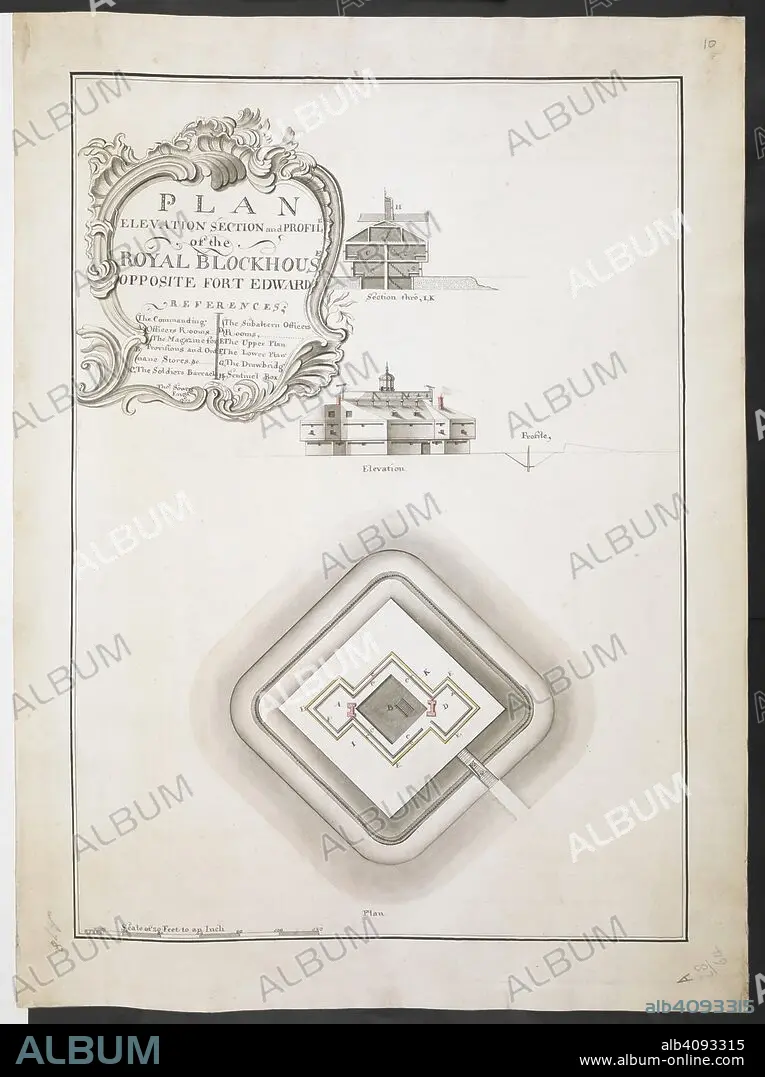
Plan elevation section and profile of the Royal Blockhouse opposite Fort Edward' by Thomas Sowers; 1759. . R.U.S.I. MAPS. Vol. LXXVI (1-13). 57711 (1-4). Places in states North-East of New York. 18th century. 1759. 1:240. 'Scale of 20 feet to an inch'. Scale bar of 120 feet (= 6 inches). 555 x 395mm. Source: Add. 57711. Amherst no. A 78. R.U.S.I. no. A 28.64.
| Partager |
|---|
 Pinterest Pinterest |
 Twitter Twitter |
 Facebook Facebook |
 Copier le lien Copier le lien |
 Email Email |
|
Ajouter à une autre Lightbox |
|
Ajouter à une autre Lightbox |


Avez-vous déjà un compte? S'identifier
Vous n'avez pas de compte ? S'inscrire
Acheter cette image.
Sélectionnez l'usage:

Légende: Voir la traduction automatique
Plan elevation section and profile of the Royal Blockhouse opposite Fort Edward' by Thomas Sowers; 1759. . R.U.S.I. MAPS. Vol. LXXVI (1-13). 57711 (1-4). Places in states North-East of New York. 18th century. 1759. 1:240. 'Scale of 20 feet to an inch'. Scale bar of 120 feet (= 6 inches). 555 x 395mm. Source: Add. 57711. Amherst no. A 78. R.U.S.I. no. A 28.64.
Plan elevation section and profile of the Royal Blockhouse opposite Fort Edward' by Thomas Sowers; 1759. . R.U.S.I. MAPS. Vol. LXXVI (1-13). 57711 (1-4). Places in states North-East of New York. 18th century. 1759. 1:240. 'Scale of 20 feet to an inch'. Scale bar of 120 feet (= 6 inches). 555 x 395mm. Source: Add. 57711. Amherst no. A 78. R.U.S.I. no. A 28.64.
Crédit: Album / British Library
Autorisations: ? Autorisation de modèle: Non - ? Autorisation de propriété: Non
Questions sur les droits?
Questions sur les droits?
Taille de l'image: 6312 × 8448 px | 152.6 MB
Taille d'impression: 53.4 × 71.5 cm | 2485.0 × 3326.0 in (300 dpi)
Mots clés: 18 18E 18EME XVIII XVIIIE XVIIIEME SIECLE • 18E SIECLE • 18EME S • DIX-HUITIÈME SIÈCLE • DOCUMENT • ÉVÉNEMENT • GUERRE • MILITAIRE • VIE MILITAIRE ET ARMEMENT • XVIIIE SIECLE
