alb4094448
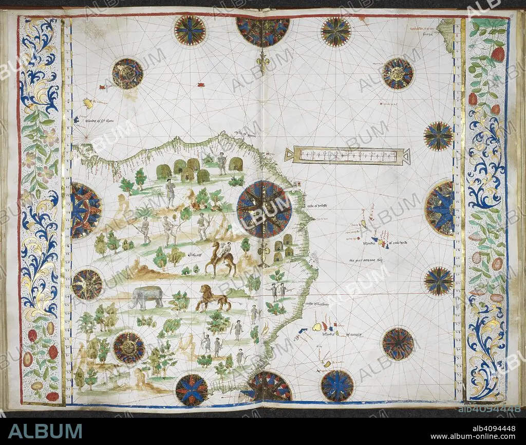
Chart of the western coast of Africa from the Gulf of Guinea to the Straits, with the adjacent isles, and a small part of the coast of South America. Jean Rotz, Boke of Idrography (The 'Rotz Atlas'). c 1535-1542. Source: Royal MS 20 E IX f.17v-18. Language: French & English.
| Partager |
|---|
 Pinterest Pinterest |
 Twitter Twitter |
 Facebook Facebook |
 Copier le lien Copier le lien |
 Email Email |
|
Ajouter à une autre Lightbox |
|
Ajouter à une autre Lightbox |


Avez-vous déjà un compte? S'identifier
Vous n'avez pas de compte ? S'inscrire
Acheter cette image.
Sélectionnez l'usage:

Auteur: JEAN ROTZ
Légende: Voir la traduction automatique
Chart of the western coast of Africa from the Gulf of Guinea to the Straits, with the adjacent isles, and a small part of the coast of South America. Jean Rotz, Boke of Idrography (The 'Rotz Atlas'). c 1535-1542. Source: Royal MS 20 E IX f.17v-18. Language: French & English.
Chart of the western coast of Africa from the Gulf of Guinea to the Straits, with the adjacent isles, and a small part of the coast of South America. Jean Rotz, Boke of Idrography (The 'Rotz Atlas'). c 1535-1542. Source: Royal MS 20 E IX f.17v-18. Language: French & English.
Crédit: Album / British Library
Autorisations: ? Autorisation de modèle: Non - ? Autorisation de propriété: Non
Questions sur les droits?
Questions sur les droits?
Taille de l'image: 6501 × 5159 px | 96.0 MB
Taille d'impression: 55.0 × 43.7 cm | 2559.4 × 2031.1 in (300 dpi)
Mots clés: 16E SIECLE • 16EME S • AFRICAIN • AFRICAINE • AFRIQUE • ANIMAL • ANIMAL: ELEPHANT • ANIMAL: LION • ANIMAUX • CARTE (GEOGRAPHIE) • CARTE GEOGRAPHIQUE • CARTE • CARTOGRAPHIE • CHAMEAU • CHAMEAUX • CÔTE • COULEUR • COULEURS • DESSIN PLANS • DOCUMENT • ELEPHANT • GENS • GRAND FELIN • LION (ANIMAL) • LION • LITTORAL • MAMMIFERE • MARITIME • PAYSAGE MARITIME AV. PLAGE • PLAN (CARTOGRAPHIE) • PLANS • ROTZ, JEAN • SCIENCE: CARTOGRAPHIE • SEIZIÈME SIÈCLE • XVIE SIECLE
